TomTom Rider Reference Guide
Contents Welcome to navigation with TomTom 6 Using your Rider 7 Mounting on a motorcycle ........................................................................................ 7 Installing in your car .............................................................................................. 9 Using the anti-theft solution ................................................................................... 10 Connecting a headset ......................................................................
The route bar ..................................................................................................... 36 Distances and the route bar ............................................................................... 37 The quick menu .................................................................................................. 37 Navigation buttons............................................................................................... 37 Other buttons ..................................
My Routes 83 About My Routes ................................................................................................. 83 Saving a route .................................................................................................... 83 Navigating using a saved route ................................................................................ 84 Adding a stop to a saved route using the map .............................................................. 84 Deleting a route from My Routes ...
Product certification 107 Finding product certification information on your device ............................................... 107 MyDrive 108 About MyDrive ................................................................................................... 108 About MyDrive Connect ........................................................................................ 108 MyTomTom account ............................................................................................
Welcome to navigation with TomTom This Reference Guide explains all you need to know about your new TomTom Rider. If you want a quick read of the essentials, we recommend that you read the Using your Rider chapter. This covers installation, planning a thrilling ride and all the main features of your device. Get going covers switching on, setting up and charging. After that, you will probably want to connect to TomTom services and you can read all about that in the Connecting to TomTom services chapter.
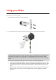
Using your Rider Mounting on a motorcycle 1. Attach the RAM™ mount kit to your motorcycle. 2. Fix the holder to the mount and connect the wires to your motorcycle's wiring system. Important: The red POS (+) contact needs to be connected to the motorcycle's wiring loom at a point between the ignition and the +12V battery supply. The black NEG (-) wire needs to be connected to the motorcycle's wiring loom at a point between the ignition and the -(GND) battery supply.
Do not overtighten nuts and screws. You may crack parts of the mount kit or damage your handlebars if you overtighten nuts or screws. If you are using the U-bolt, don’t forget to put the provided rubber caps over the exposed threads. Important: Damage due to modifications, improper installation, road hazards or accidents, are not covered.
Installing in your car If your box contains a car mount, use the supplied mount to install your TomTom Rider in your vehicle. Read the instructions about positioning your device before you install your Rider. If your box contains a car mount, install your Rider by doing the following: 1. Connect the supplied USB cable to the holder. Note: Use ONLY the USB cable supplied with your Rider. Other USB cables may not work. 2.
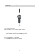
Tip: With the High-Speed Dual Charger you can charge your TomTom Rider and smartphone at the same time. Using the anti-theft solution If your box includes an anti-theft solution, it is supplied in two parts: A RAM lock for the mount. This lock prevents the unscrewing of the RAM arm from the motorcycle. A lock for the TomTom Rider itself. This lock prevents the disconnection of the TomTom Rider from the dock.
Note: Make sure you use the longer screws provided with your Rider lock. 2. Lock your TomTom Rider to prevent removal from the mount. Unscrew the wingnut from the RAM arm and attach the RAM lock. Connecting a headset We recommend using a compatible headset with your TomTom Rider to hear spoken instructions and hear warning sounds on your TomTom Rider. This makes riding with your TomTom Rider as safe as possible. For more information and a full list of compatible headsets, go to tomtom.com/riderheadsets.
The instructions below describe how to set up a Bluetooth® headset. If you did not establish a Bluetooth connection between your Bluetooth headset and your TomTom Rider when you first turned your TomTom Rider on, you can establish the connection at any time by doing the following: 1. 2. 3. 4. 5. Turn the headset on by following the user instructions for your headset. From the Main Menu, select Settings. Select Bluetooth Connections.
Search Plan a Thrill My Routes Select this button to search for an address, a place or a Point of Interest, then plan a route to that location. Select this button to plan a thrilling ride for a round trip or to a destination. Select this button to show your saved routes, recorded routes and imported routes. Current Route / Current Track Select this button to clear or change your planned route. Start Recording Select this button to start or stop recording a track.
Connected Services Trip Statistics Select this button to see the status of your connection to the internet. Select this button to see trip statistics about how far you've been riding, how long you've been riding, and also at what speed. Planning a thrilling route You can use the Plan a Thrill button to create interesting rides on the spot. This is especially useful for a day when you have some spare time and just need a simple way to create a thrilling ride.
Your Rider plans a thrilling round trip through your chosen stop. Tip: The direction of the round trip is random. If you have at least two stops on your route, you can change the direction of travel by reordering the stops. Arrows on the planned route show the direction of travel. 5. If you want to add more stops to your route, move the map and select more stops. Your Rider plans a thrilling round trip route through your chosen stops. Tip: Select the pop-up menu button to reorder your stops. 6.
1. Select the Main Menu button to open the Main Menu. 2. Select Plan a Thrill. The map view opens. 3. Select a location by pressing and holding the screen for about one second. 4. Select the destination button. Your Rider plans a thrilling route to your chosen destination. 5. If you want to add more stops to your route, move the map and select more stops. Your Rider plans a thrilling route through your chosen stops to your destination. Tip: Select the pop-up menu button to reorder your stops. 6.
7. When you have planned your thrilling route, select Ride. Your route is shown on the map view, then guidance along your route begins. As soon as you start riding, the guidance view is shown automatically. Looking at trip statistics Your Rider can show you how far you've been riding, how long you've been riding, and also at what speed. To see trip statistics, select Trip Statistics in the Main Menu. Select one of the three tabs to see statistics for today's riding, for your current trip and for all-time.
To use quick settings, select the quick settings button in the main menu, the map view or the guidance view. You see the screen shown below with large buttons and a volume control: Tip: When wearing gloves, select the plus (+) and minus (-) buttons beneath the volume slider to change the volume, instead of trying to move the slider with gloves on.
Recording a track You can record a track while riding your bike, with or without a route planned beforehand. After recording, you can then export your track so that you can share it with friends or view it on Tyre Pro. To record a track, do the following: 1. In the Main Menu, select Start Recording. A red dot appears in the lower right-hand corner of the screen and initially flashes three times to show that you are now recording. The dot remains on the screen until you stop recording. 2.
Sharing routes Installing Tyre Pro You can use Tyre Pro® to search, create and edit routes on your computer before you upload them to your TomTom Rider. To get free access to Tyre Pro®, follow the steps below: 1. Go to tomtom.com/getstarted and select your country. 2. Connect your Rider to your computer to link your device to your account and register with us. 3. Within 24 hours you will receive an email with a unique Tyre code and URL. Use this code and URL to activate and download your Tyre Pro® software.
Share the file with friends by exporting it to a memory card. Note: Tracks can be imported and exported. ITN files (TomTom's own Itinerary file format) An ITN file contains less detail than a GPX file. An ITN file can contain a maximum of 255 locations which is enough to recreate a route accurately. ITN files become routes after import.
3. Select one or more routes from the list on your memory card for import. Tip: To select or deselect all routes, select the pop-up menu button. 4. Select Import. You see the message Importing routes. Your routes are imported onto your device. 5. When you see a message that your routes have been imported successfully, remove your memory card. 6. To view your imported routes and tracks, select My Routes in the Main Menu.
Note: Each exported route is saved as a GPX file in folder TomTom Routes on your memory card. The glove-friendly keyboard Switching to the glove-friendly keyboard The glove-friendly keyboard has large buttons so that you can make selections more easily while wearing motorcycle gloves. See Entering search terms for instructions on how to select different keyboard layouts. Using the glove-friendly keyboard Taking the "pqrs" key as our example, do the following: 1.
Bluetooth Connections Select Settings in the Main Menu, then select Bluetooth Connections. Connecting a headset Select Search for headset and follow the instructions.
What's new New in this release Make your own wake-up phrase for Voice Control Think of your own unique phrase and use it to start Voice Control. To learn more, go to Voice Control in this guide. Instructions for rotating a device with an integrated mount If your device has an integrated mount, you can easily change the rotation of your device to make mounting the device in your car easier. To learn more, go to Installing in your car in this guide.
Get going Positioning the device Be careful where you install your Rider. The Rider shouldn't block or interfere with any of the following: Your view of the road. The controls in your vehicle. Your rearview mirrors. The airbags. You should be able to reach your Rider easily without leaning or stretching. In a car, you can attach your Rider to the windshield or side window or you can use a Dashboard Mount Disk to attach the mount to your dashboard.
To ensure good satellite reception, use your Rider outdoors and keep it upright. Large objects such as tall buildings can sometimes interfere with reception. Important: QuickGPSFix contains information about satellite positions which helps your Rider find your position faster. QuickGPSFix information is sent to Always Connected devices in real time and to Smartphone Connected devices when connected to TomTom services using your smartphone. You can also update QuickGPSFix using MyDrive.
You are warned when the battery level is low or critical. You lose your connection to some TomTom services when the battery level is low or critical. When the battery is empty, your Rider goes into sleep mode. Note: Use ONLY the USB cable supplied with your Rider. Other USB cables may not work. Caring for your Rider It is important to take care of your device: Do not open the casing of your device under any circumstances. Doing so may be dangerous and will void the warranty.
Connecting to TomTom services About TomTom services TomTom services give you real-time information about traffic and safety cameras on your route. To get TomTom services on your Rider you need the following items: Any Rider. A smartphone with a data plan from a mobile services provider. The TomTom MyDrive app for iOS or Android installed on your smartphone. A MyTomTom account. Using TomTom services means that data is sent and received by your phone using your mobile services provider.
Notifications Your smartphone displays a notification when the TomTom MyDrive app is connected to your Rider. Main menu Tap the app Main Menu button to show the main menu. The menu has the following items: Status - shows the status screen where you can see the status of the connection. Traffic - shows a map of your location with traffic incidents. MyTomTom Account - lets you log in to your MyTomTom account. Settings - lets you change the app settings.
Bluetooth not connected. Bluetooth connecting. Your device is trying to automatically connect to your phone. Bluetooth connected. Your device is connected to your phone. You can also connect using another phone. Connect to TomTom services using a different smartphone 1. Turn on Bluetooth on your phone, and make sure that your phone is discoverable (iOS) or visible (Android). 2. Start the TomTom MyDrive app on your phone. 3. Select Connected Services in the Main Menu. 4. Select Traffic & Safety Cameras.
Your phone is shown on your TomTom navigation device. Your phone's Bluetooth is turned on. The TomTom MyDrive app is started on your phone. Your data plan with your mobile services provider is active, and you can access the internet on your phone.
What's on the screen The map view The map view is shown when you have no planned route. Your actual location is shown as soon as your Rider has found your GPS location. You can use map view in the same way as you might look at a traditional paper map. You can move around the map using gestures, and zoom using the zoom buttons.
1. Back button. This button returns the map to an overview of your whole route or, if no route is planned, moves the map to put your current location at the center. 2. Switch view button. Select the switch view button to change between the map view and the guidance view. When in map view, if you are driving, the small compass arrow rotates to show your current driving direction, with north being up.
Tip: When you have planned a route and the 3D guidance view is shown, select the switch view button to change to the map view and use the interactive features. When your Rider starts after sleeping and you have a route planned, you are shown the guidance view with your current location. 1. Switch view button. Select the switch view button to change between the map view and the guidance view. 2. Zoom buttons. Select the zoom buttons to zoom in and out.
7. Current location. This symbol shows your current location. Select the symbol or the speed panel to open the quick menu. Note: If your Rider cannot find your location using GPS or other methods, the symbol appears gray. 8. Route bar. The route bar is shown when you have planned a route. Important: To see a wider route bar showing additional route information, change the setting for Route Information. The route bar The route bar is shown when you have planned a route.
the symbols. For a complete list of incident types, see Traffic incidents. The bottom of the route bar represents your current location and shows the distance to the next incident on your route. In addition, you can choose to see the current time if you turn the setting on. Note: To make the route bar more readable some incidents may not be shown. These incidents will always be of minor importance and only cause short delays.
Search Select this button to search for an address, a place or a Point of Interest, then plan a route to that location. Current route Select this button to clear or change your planned route. Report Safety Camera Select this button to report a safety camera. My Places Select this button to show your saved places. My Routes Select this button to show your saved routes. Parking Gas Station Select this button to find parking lots/garages. Select this button to find gas stations.
Voice Recognition Select this button to start voice recognition. Tip: You can also say the wake-up phrase to start voice recognition. Activate Traffic Connected Services Select this button to connect to TomTom services. Select this button to see the status of your connection to the internet. Other buttons On the map or guidance view, select the Main Menu button to open the Main Menu.
This symbol shows that your Rider is connected to TomTom services. This symbol shows that your Rider is not connected to TomTom services. Select this button to turn off voice instructions. You will no longer hear spoken route instructions but you will still hear information such as traffic information and warning sounds. Tip: You can select the types of instructions you want to hear. Select Voices in the Settings Menu and select the instructions you want to hear.
Double tap Touch one finger on the screen twice in rapid succession. Example of when to use this: Zooming in on the map. Drag Put one finger on the screen and move it across the screen. Example of when to use this: Scrolling around in the map. Flick Flick the tip of a single finger across the screen. Example of when to use this: Scrolling a long distance on the map. Tip: Flick isn't available on all devices. Press and hold Put one finger on the screen for more than one half second.
Traffic About TomTom Traffic TomTom Traffic is a unique TomTom service providing real-time traffic information. For more information about TomTom services, go to tomtom.com/services. In combination with IQ Routes, TomTom Traffic helps you plan the optimum route to your destination taking into account the current local traffic conditions and the weather. Your TomTom Rider regularly receives information about the changing traffic conditions.
The arrival information panel shows the following information: The estimated time that you will arrive at your destination. The length of time to drive to the destination from your current location. A parking button is shown near the destination flag when parking is available near your destination. Tip: If your destination is in a different time zone, you see a plus (+) or a minus (-) sign and the time difference in hours and half hours in the arrival information panel.
Tip: Select an incident on the map to see more detailed information. 1. Traffic incident that affects your route in your direction of travel. A symbol or number at the start of the incident shows the type of incident or the delay in minutes, for example 5 minutes. The color of the incident indicates the speed of traffic relative to the maximum allowed speed at that location, with red being the slowest. The stripes on the traffic jam are also animated to show the speed of the traffic, where appropriate.
To get more information about an incident, select an incident in the route bar. The map opens zoomed in on the incident and a pop-up opens showing detailed information about the traffic incident. The information shown includes: The type of traffic incident – general, accident, roadwork, lane closure or weather such as heavy rain or snow. The severity of the incident - slow traffic, traffic lining up or stationary traffic. The delay time. The length of the incident.
Unknown incident Road work Lane closure Road closure Advanced Lane Guidance Note: Lane guidance is not available for all crossings or in all countries. Advanced Lane Guidance helps you prepare for highway exits and crossings by showing the correct driving lane for your planned route. As you approach an exit or crossing, the lane you need is shown on the screen and in the instruction panel. Tip: To close the lane image, select anywhere on the screen or press the back button.
Important: The speed limit shown in the speed panel is only an indication. You must always obey the actual speed limit for the road you are on and the conditions you are driving in.
Using Quick Search About search You use search to find a wide range of places and then navigate to them. You can search for the following: A specific address, for example, 335 Madison Avenue, New York. A partial address, for example, Madison Ave NY. A type of place, for example, gas station or restaurant. A place by name, for example, Starbucks. A ZIP code, for example, 36925 York for York, Alabama. A city to navigate to a city center, for example, Kingston, NY.
Tip: If you press and hold a letter key on the keyboard, you get access to extra characters if they are available. For example, press and hold the letter "e" to access characters 3 e è é ê ë and more. You can search for a POI (Point of Interest) type, such as a restaurant or tourist attraction. Alternatively, you can search for a specific POI, for example "Rosie's Pizzeria." Note: When searching, the whole map is searched.
6. To see more information about the POI, select the POI on the map and then select the pop-up menu button. Select More Information on the pop-up menu. You see more information about the POI such as the phone number, full address, and email. 7. To plan a route to this destination, select the drive button: A route is planned and then guidance to your destination begins. As soon as you start driving, the guidance view is shown automatically.
The search results are shown in two columns. 2. Select Search Places Online. 3. Use the keyboard to enter the name of the POI you want to find, then press the Search button on the keyboard. Tip: If you press and hold a letter key on the keyboard, you get access to extra characters if they are available. For example, press and hold the letter "e" to access characters 3 e è é ê ë and more. You can search for a POI (Point of Interest) type, such as a restaurant or tourist attraction.
5. To see more information about the POI, select the POI on the map and then select the pop-up menu button. Select More Information on the pop-up menu. You see more information about the POI such as the phone number, full address, and email. 6. To plan a route to this destination, select the drive button: A route is planned and then guidance to your destination begins. As soon as you start driving, the guidance view is shown automatically.
1. Back button. Select this button to go back to the previous screen. 2. Search input box. Enter your search term here. As you type, matching addresses and POIs are shown. Tip: If you press and hold a letter key on the keyboard, you get access to extra characters if they are available. For example, press and hold the letter "e" to access characters 3 e è é ê ë and more. Tip: To edit, select a word you have already typed to place the cursor. You can then insert or delete characters. 3. Type of search.
8. Show/hide keyboard. Select this button to show or hide the keyboard. Tip: Select the Shift key once to make the next letter you type upper case. Double tap the Shift key to use Caps-Lock where all the letters you type are upper case. Select the Shift key once to quit Caps-Lock. Tip: To cancel a search, select the map/guidance view button in the top right-hand corner of the screen. Working with search results Your search results are shown in two columns.
If you show the result on the map, you can use the pop-up menu to add a location from My Places or search near this location. If a route is already planned, you can add the location to your current route. Note: The best search results are shown on the map. When you zoom in, the lower ranked search results are gradually shown. About ZIP codes You can search using a ZIP code to get closer to the area in which you want to find an address or POI.
Court house ATM Legal - Attorneys Bank Legal - other services Food services Convenience store Fast food restaurant Restaurant Chinese restaurant Accommodation Hotel or motel Luxury hotel Campground Economy chain hotel Emergency services Hospital or clinic Dentist Police station Veterinarian Doctor Fire station Car-related services Outside parking Gas station Parking garage Car wash Car dealer Vehicle inspection center 56
Rental car facility Electric/hybrid car charging point(s) Rental car parking Car repair facility Other services Embassy Pet services Government office Telecommunication Company Community service Post office Pharmacy Shopping center Beauty services Tourist information office Shop College or university School Library Convention center Casino Winery Theater Tourist attraction Movie Theater Zoo Education Leisure 57
Concert hall Amusement park Museum Exhibition center Opera Cultural center Nightlife Leisure center Sports Park Swimming pool Mountain peak Water sports Beach Tennis court Park or recreation area Ice skating rink Yacht basin or marina Sports center Stadium Golf course Church Place of worship Railroad station Mountain pass Airport Scenic or panoramic view Sport Religion Travel 58
Ferry terminal ZIP code Note: Not used in all countries.
Planning a route Planning a route to an address using search Important: In the interest of safety and to avoid distractions while you are driving, you should always plan a route before you start driving. To plan a route to an address using search, do the following: 1. Select the Main Menu button to open the Main Menu. 2. Select Search. The search screen opens with the keyboard showing. 3. Use the keyboard to enter the name of the place you want to plan a route to.
Towns and roads are shown on the left, POIs are shown on the right. Tip: To see more results, hide the keyboard or swipe the results list to scroll it. Tip: You can switch between seeing the results on the map or in a list by selecting the list/map button: 5. Select an address suggestion. 6. Enter the house number if you have one and haven't entered it already. Tip: If you enter a house number that is not found, the number appears red. The nearest house number that is found is shown in the Drive button.
Planning a route to a city center Important: In the interest of safety and to avoid distractions while you are driving, you should always plan a route before you start driving. To plan a route to a city center using search, do the following: 1. Select the Main Menu button to open the Main Menu. 2. Select Search. The search screen opens with the keyboard showing. 3. Use the keyboard to enter the name of the city or town you want to plan a route to.
5. Select the city in the left-hand column. The city name is shown in the right side of the search input box, and the city center POI is shown below in the right-hand column. 6. Select the city center POI. The city center location is shown on the map. 7. Select Drive. Your navigation device plans a route then starts to guide you to your destination. As soon as you start driving, the guidance view is shown automatically.
2. Select Search. The search screen opens with the keyboard showing. 3. Use the keyboard to enter the name of the place you want to plan a route to. Tip: If you press and hold a letter key on the keyboard, you get access to extra characters if they are available. For example, press and hold the letter "e" to access characters 3 e è é ê ë and more. You can search for a POI (Point of Interest) type, such as a restaurant or tourist attraction.
Tip: You can switch between seeing the results on the map or in a list by selecting the list/map button: 5. Select a POI type or an individual POI. If you selected a POI type, select a POI. The location is shown on the map. 6. To see more information about the POI, select the POI on the map and then select the pop-up menu button. Select More Information on the pop-up menu. You see more information about the POI such as the phone number, full address, and email. 7.
The search results are shown in two columns. 2. Select Search Places Online. 3. Use the keyboard to enter the name of the POI you want to find, then press the Search button on the keyboard. Tip: If you press and hold a letter key on the keyboard, you get access to extra characters if they are available. For example, press and hold the letter "e" to access characters 3 e è é ê ë and more. You can search for a POI (Point of Interest) type, such as a restaurant or tourist attraction.
5. To see more information about the POI, select the POI on the map and then select the pop-up menu button. Select More Information on the pop-up menu. You see more information about the POI such as the phone number, full address, and email. 6. To plan a route to this destination, select the drive button: A route is planned and then guidance to your destination begins. As soon as you start driving, the guidance view is shown automatically.
2. When you have found your destination on the map, select it by pressing and holding the screen for about one second. A pop-up menu shows the nearest address. 3. To plan a route to this destination, select the drive button: A route is planned and then guidance to your destination begins. As soon as you start driving, the guidance view is shown automatically. Tip: You can use the location you selected in other ways, such as adding it to My Places, by selecting the pop-up menu button.
2. Select My Places. A list of all your Places opens. 3. Select the Place you want to navigate to, for example Home. Your chosen Place is shown on the map with a pop-up menu. 4. To plan a route to this Place, select the drive button: A route is planned and then guidance to your destination begins. As soon as you start driving, the guidance view is shown automatically.
Planning a route using coordinates Important: In the interest of safety and to avoid distractions while you are driving, you should always plan a route before you start driving. To plan a route using a pair of coordinates, do the following: 1. Select the Main Menu button to open the Main Menu. 2. Select Search. The search screen opens with the keyboard showing. 3. Select the type of search button to the right of the search box. 4. Select Latitude Longitude. 5. Type in your pair of coordinates.
8. To plan a route to this destination, select the drive button: A route is planned and then guidance to your destination begins. As soon as you start driving, the guidance view is shown automatically. Tip: If your destination is in a different time zone, you see a plus (+) or a minus (-) sign and the time difference in hours and half hours in the arrival information panel. The estimated time of arrival is the local time at your destination. Tip: You can add a stop to a route that you have already planned.
A route is planned and then guidance to your destination begins. As soon as you start driving, the guidance view is shown automatically. Tip: If your destination is in a different time zone, you see a plus (+) or a minus (-) sign and the time difference in hours and half hours in the arrival information panel. The estimated time of arrival is the local time at your destination. Tip: You can add a stop to a route that you have already planned. Tip: You can save a route using My Routes.
1. Select the Main Menu button to open the Main Menu. 2. Select Search. 3. 4. 5. 6. The search screen opens with the keyboard showing. Use the keyboard to enter the name of the location you want to use as a starting point. Select an address or POI suggestion. Select Show on Map. Select the pop-up menu button. A pop-up menu shows a list of options. 7. Select Use as Starting Point. 8.
A pop-up menu shows a list of options. 3. Select Remove Starting Point. Your route is replanned with your current location as the starting point. Changing the starting point into a stop 1. Select the starting point on the route in the map view. 2. Select the pop-up menu button. A pop-up menu shows a list of options. 3. Select Change to a Stop. Your route is replanned with the starting point changed into a stop. Finding a parking lot To find a parking lot, do the following: 1.
The map opens showing the locations of parking lots. If a route is planned, the map shows parking lots near your destination. If a route isn't planned, the map shows parking lots near your current location. You can change the screen to show a list of parking lots by pressing this button: You can select a parking lot from the list to locate it on the map. Tip: You can scroll down the list of results using the scroll bar on the right side of the screen.
3. Select a parking lot from the map or the list. A pop-up menu opens on the map showing the name of the parking lot. 4. To plan a route to your chosen parking lot, select the drive button: A route is planned and then guidance to your destination begins. As soon as you start driving, the guidance view is shown automatically. Tip: You can add a parking lot as a stop on your route by using the pop-up menu. Finding a gas station To find a gas station, do the following: 1.
If a route is planned, the map shows gas stations along your route. If a route isn't planned, the map shows gas stations near your current location. You can change the screen to show a list of gas stations by pressing this button: You can select a gas station from the list to locate it on the map. Tip: You can scroll down the list of results using the scroll bar on the right side of the screen. If you want to change how the search is done, select the button to the right of the search box.
4. To plan a route to your chosen gas station, select the drive button: A route is planned and then guidance to your destination begins. As soon as you start driving, the guidance view is shown automatically. Tip: You can add a gas station as a stop on your route by using the pop-up menu. A gas station that is a stop on your route has a blue icon.
Changing your route The Current Route Menu When you have planned a route or track, select the Current Route button in the Main Menu to open the Current Route Menu. The following buttons are available in the menu: Clear Route or Track Find Alternative Avoid Blocked Road Select this button to clear the currently planned route or track. The Current Route Menu closes and you return to the map view. You see this button when you have planned a route.
Add to My Routes If you plan a new route that has not already been saved, you see this button. Select this button to save this route as part of your My Routes list. Save Changes to Route If you make a change to a My Route, you see this button. Select this button to save the changes. Change Route Type Reorder Stops Select this button to change the type of route used to plan your route. Your route will be recalculated using the new route type.
Note: It may not be possible to find an alternative route around the blocked road if none exists. 3. Select the new route by selecting the time balloon. 4. Select Let's go. Guidance to your destination resumes avoiding the blocked road. As soon as you start driving, the guidance view is shown automatically. Types of route Select Change Route Type to change the type of route planned to your current destination. Your route is recalculated using the new route type.
Select Search and search for a location. When you have found a location, select the Add Stop to Route button. Your route is recalculated to include your stop. Adding a stop to your route using the map 1. Press the switch view button to show the map. Your complete route is shown on the map. 2. Zoom in on the map, then press and hold to select a location. 3. Select the pop-up menu button. 4. Select Use in Route. 5. Select Add to Current Route. Your route is recalculated to include your stop.
My Routes About My Routes My Routes provides an easy way to create saved routes with optional stops, sometimes known as an itinerary. You can use My Routes to save, retrieve and edit routes. You may want to use My Routes in one or more of the following situations: While working - Your job involves driving several routes with multiple stops on a daily basis. Your routes can change and you need to be flexible and be able to change the order of your stops or change the planned route.
Navigating using a saved route To navigate using a previously saved route, do the following: 1. In the Main Menu, select My Routes. 2. Select a route from your list. The route is shown on the map view. 3. To navigate to the start of the saved route, select Drive. The starting point of the saved route is converted to your first stop and then the route is planned. Guidance to your destination begins from your current location. As soon as you start driving, the guidance view is shown automatically.
3. Select the pop-menu button to open the menu. 4. Select Manage Stops. 5. Select Add Stop to Route. 6. Select your new stop on the map. Tip: If you know the name of your new stop, you can use Search to select your stop instead of using the map. 7. Select the Add Stop button to add this location as a stop. Your route is recalculated to include your stop. Tip: To update the saved route in your My Routes list with the changes, select the route on the map, then select Save Changes to Route in the pop-up menu.
My Places About My Places My Places provides an easy way to select a location without the need to search for the location each time. You can use My Places to create a collection of useful addresses. The following items are always in My Places: Home - Your home location can be your home address or somewhere you often visit, such as your office. This feature provides an easy way to navigate there.
Setting your home location using the map 1. In the Map View, move the map and zoom in until you can see your home location. 2. Select the location by pressing and holding the screen for about one second. A pop-up menu shows the nearest address. 1. Open the pop-up menu and select Add to My Places. 2. In the name bar, enter the name "Home". Note: "Home" must have a capital letter H. 3. Select Add. Your home location is shown on the map.
Adding a location from My Places 1. In the Main Menu, select My Places. 2. Select Add a new place. 3. To select a location, do one of the following: Zoom in on the map at the location you want to select. Press and hold to select the location, then select the add location symbol. Search for a location. Select Show on Map, then select the add location symbol. The name of the location appears in the edit screen. 4. Edit the name of the location so you can easily recognize it. 5.
5. Select Add to My Places. The name of the location appears in the edit screen. 6. Edit the name of the location so you can easily recognize it. 7. Select Done to save your location in the My Places list. Adding a location to My Places by marking To mark a location and temporarily add it to My Places, do the following: 1. Make sure that your current location is the location you want to mark. 2. Select the current location symbol or the speed panel in the guidance view to open the quick menu. 3.
Map Share About Map Share You can report map corrections using Map Share. These map corrections are then shared with other TomTom users when they receive a map update. There are two ways to report a map correction: Select a location on the map and create the correction report immediately. Mark a location and create the correction report later. To send your map correction reports to TomTom, you must connect your Rider to your computer and use MyDrive.
Note: If you want to report a map correction of a type not shown in the menu, use the Map Share Reporter at tomtom.com. 5. Follow the instructions for your chosen type of map correction. 6. Select Report. 7. Connect your Rider to MyDrive to send your map correction report to TomTom and receive map corrections from other TomTom users. Creating a map correction report from a marked location If you see a map error while you are driving, you can mark the location so you can report the error later.
6. Select the type of map correction you want to apply. Note: If you want to report a map correction of a type not shown in the menu, use the Map Share Reporter at tomtom.com. 7. Follow the instructions for your chosen type of map correction. 8. Select Report. The marker for the marked location is removed from the map. 9. Connect your Rider to MyDrive to send your map correction report to TomTom and receive map corrections from other TomTom users.
5. Enter the correct street name. 6. Select Report. Turn Restriction Select this option to report incorrect road turn restrictions. 1. 2. 3. 4. 5. 6. Press and hold to select the location of the map correction on the map view. Select the pop-up menu button to open the menu. Select Report Map Error from the pop-up menu. Select Turn Restriction. If the incorrect crossing is shown, choose Select another crossing. Select the approach direction.
Safety Cameras About safety cameras The Safety Cameras service warns you about the following camera locations: Fixed safety camera locations. Speed trap locations. Speed trap hotspots. Average safety camera locations. Speed enforcement zones. Red light camera locations. Traffic restriction cameras. The Safety Cameras service also warns you about the following safety hazards: Accident blackspot locations. Traffic jams.
Symbol shown on map Symbol shown in route bar Description Speed trap - this type of camera checks the speed of passing vehicles and can be moved to different locations. Speed trap hotspots - this type of warning shows places where speed traps are often used. Average speed safety cameras - these types of cameras measure your average speed between two points. You are warned at the start and end of the average speed zone.
Changing the way you are warned To change the way you are warned about safety cameras, select the Sounds and Warnings button in the Settings menu. You can then set how you want to be warned for the different types of cameras and safety hazards. You can change settings for whether you want to be warned, never warned or warned only if you are speeding. For example, to change how you are warned when you approach a safety camera, do the following: 1. 2. 3. 4. Select Sounds and Warnings in the Settings Menu.
2. Select Report Safety Camera. You see a message thanking you for adding the camera. Tip: If you make a mistake when reporting a camera, select Cancel in the message. The safety camera is saved on your Rider automatically and also sent to other users. Confirm or remove a speed trap You can confirm the presence of a speed trap or remove a speed trap if it is no longer present. 1. Just after you pass a speed trap, in the route bar you are asked if the camera was still there. 2.
Settings Appearance Select Settings in the Main Menu, then select Appearance. On this screen, you can change these settings: Display Select Display to change the appearance of the display. Route bar Select Route bar to change the information you see in the route bar. Guidance view Select Guidance view to change the information you see in the guidance view. Automatic zoom Select Automatic Zoom to change how you view a crossing as you drive.
Size of text and buttons Select Size of text and buttons to change the size of the text and the buttons you see on the screen. Note: This feature is only available on devices with a 6 inch / 15 cm or larger screen. Drag the slider to change the text and button size to small, medium or large, then select Apply this change. Your Rider restarts and applies the change. Route Bar Select Settings in the Main Menu, then select Appearance.
Arrival information Select Arrival information to change the following settings: Show remaining distance Select this setting to show the remaining distance left to travel in the arrival information panel during navigation. Show remaining time Select this setting to show the remaining time left to travel in the arrival information panel during navigation.
Select Automatic zoom to change settings for the automatic zoom in Guidance view when you approach a turn or a junction. Zooming in can make the turn or junction easier to drive. Zoom in to next turn All the turns and junctions on your route are shown zoomed in to the maximum level. Based on road type The turns and junctions on your route are shown zoomed in to the standard level for the type of road you are on. None None of the turns and junctions on your route are shown zoomed in.
Maps Select Settings in the Main Menu, then select Maps. Changing the map Select Change map to change the map that you are using. You can choose from maps stored either in internal memory or memory cards if your Rider has a memory card slot. Note: Although you can store more than one map on your Rider, you can only use one map at a time for planning and navigation. Route Planning Select Settings in the Main Menu, then select Route Planning.
Sounds and Warnings Select Settings in the Main Menu, then select Sounds & Warnings. On this screen, you can change the sounds and warnings settings. Safety camera warnings Select Settings in the Main Menu, then select Sounds & Warnings. Select Safety camera warnings. You can then set how you want to be warned for the different types of cameras and safety hazards. You can change settings for advance warning time and whether you want to be warned, never warned or warned only if you are speeding.
Screen touch sounds Select Settings in the Main Menu, then select Sounds & Warnings. Switch on Screen touch sounds to hear a click when you select an item or touch a button. The click sound means that your selection or touch has been understood. Read traffic warnings out loud Select Settings in the Main Menu, then select Sounds & Warnings. Switch on Read traffic warnings out loud to hear spoken warnings about traffic on your route.
System Select Settings in the Main Menu, then select System. On this screen, you can change these settings: About This is an information screen rather than a setting and shows you information about your TomTom Rider. You may be asked to go to this screen during a call to TomTom Customer Support or you may need to enter information taken from this screen when using the TomTom Shop.
Getting Help Help Select Help from the Main Menu or the Settings menu. On this screen, you can see the following information: Guided tour Select this option to get a short tutorial on how to use your navigation device. About See System. More help You can get further help by going to tomtom.com/support. For warranty and privacy information, go to tomtom.com/legal.
Product certification Finding product certification information on your device To find product certification information, such as the ICASA-approved certification number, do the following on your Rider: 1. Select Settings in the Main Menu. 2. Select System. 3. 4. 5. 6. Select About. Select Legal information. Select Certificates. You then see the relevant product certification information for your Rider, for example, ICASA.
MyDrive About MyDrive MyDrive is a web-based tool that helps you manage the contents and services of your TomTom Rider. For example, you can use MyDrive to get map updates, software updates or manage your MyTomTom account. You log in to MyDrive on the TomTom website. It is a good idea to frequently connect your Rider to MyDrive to ensure you always have the latest updates. Tip: We recommend using a broadband internet connection whenever you connect your Rider to MyDrive.
Note: You cannot use the holder to connect your Rider to your computer. Note: You should plug the USB cable directly into a USB port on your computer and not into a USB hub or USB port on a keyboard or monitor. 5. Enter the requested information for account creation, including your country. When set-up is complete, a MyTomTom account is created and your Rider is linked to that account. You can now access MyDrive Connect from the notification area on your desktop.
Addendum Important Safety Notices and Warnings Global Positioning System (GPS) and Global Navigation Satellite System (GLONASS) The Global Positioning System (GPS) and Global Navigation Satellite System (GLONASS) systems are satellite-based systems that provide location and timing information around the globe. GPS is operated and controlled by the Government of the United States of America, which is solely responsible for its availability and accuracy.
Prohibited uses Aircraft and hospitals Use of devices with an antenna is prohibited on most aircraft, in many hospitals and in many other locations. This device must not be used in these environments.
THE BATTERY CONTAINED IN THE PRODUCT MUST BE RECYCLED OR DISPOSED OF PROPERLY ACCORDING TO THE LOCAL LAWS AND REGULATIONS AND ALWAYS KEPT SEPARATE FROM HOUSEHOLD WASTE. BY DOING THIS YOU WILL HELP CONSERVE THE ENVIRONMENT. USE YOUR TOMTOM DEVICE ONLY WITH THE SUPPLIED DC POWER CORD (CAR CHARGER/BATTERY CABLE), AC ADAPTER (HOME CHARGER), IN AN APPROVED CRADLE OR USING THE SUPPLIED USB CABLE TO CONNECT TO A COMPUTER FOR BATTERY CHARGING.
Operation is subject to the following two conditions: (1) this device may not cause harmful interference and (2) this device must accept any interference, including interference that may cause undesired operation of the device. This device has been tested and found to comply with the limits for a Class B digital device, pursuant to part 15 of the FCC rules. These limits are designed to provide reasonable protection against harmful interference in a residential installation.
This GPS Navigation System is a radio transmitter and receiver. It is designed and manufactured not to exceed the emission limits for exposure to radio frequency (RF) energy set by the Federal Communications Commission (FCC) of the U.S. Government, Industry Canada of the Canadian Government (IC). The SAR limit recommended by the Federal Communications Commission (FCC) of the U.S. Government, Industry Canada of the Canadian Government (IC) is 1.6W/kg averaged over 1 gram of tissue for the body (4.
Exposure limits This equipment complies with IC radiation exposure limits set forth for an uncontrolled environment. End users must follow the specific operating instructions for satisfying RF exposure compliance. To maintain with IC RF exposure compliance requirements, please follow the operation instructions in this manual. Limites d'exposition Cet équipement est conforme aux limites d'exposition aux rayonnements définies pour un environnement non contrôlé.
This document Great care was taken in preparing this document. Constant product development may mean that some information is not entirely up to date. The information in this document is subject to change without notice. TomTom shall not be liable for technical or editorial errors or omissions contained herein, nor for incidental or consequential damages resulting from the performance or use of this document. This document contains information protected by copyright.
Copyright notices © 2015 TomTom. All rights reserved. TomTom and the "two hands" logo are registered trademarks of TomTom N.V. or one of its subsidiaries. Please see tomtom.com/legal for limited warranty and end user license agreements applying to this product. © 2015 TomTom. All rights reserved. This material is proprietary and the subject of copyright protection and/or database rights protection and/or other intellectual property rights owned by TomTom or its suppliers.