TomTom VIA User Manual 17.
Contents Welcome to navigation with TomTom 6 Get going 7 Installing in your car .............................................................................................. 7 Positioning the device ............................................................................................ 7 Turning on and off ................................................................................................. 7 Setting up ...................................................................................
Step by step search 30 Using step-by-step search ...................................................................................... 30 About search .................................................................................................. 30 Entering search terms ....................................................................................... 30 Working with search results ................................................................................ 31 About ZIP codes ...............
Safety Cameras 70 About safety cameras ........................................................................................... 70 Crossing into another area or country ....................................................................... 70 Safety camera warnings ........................................................................................ 70 Changing the way you are warned ............................................................................
TomTom account 90 Addendum 91 Copyright notices 97 5
Welcome to navigation with TomTom This User Manual explains all you need to know about your new TomTom VIA navigation device. To learn about getting started with your device and installing it in your vehicle, we recommend that you read the Get going chapter. After that, you will probably want to learn about searching for an address or Point of Interest, and you can read all about that in the Step-by-step search chapter. For information about what you see on the device itself, go to What's on the screen.
Get going Installing in your car Use the supplied mount to install your TomTom VIA in your vehicle. Read the instructions about positioning your device before you install your VIA. To install your VIA, do the following: 1. Connect the supplied USB cable to the mount. If the mount is integrated into your VIA, connect the USB cable to the device. Note: Use ONLY the USB cable supplied with your VIA. Other USB cables may not work. 2.
You can also press the On/Off button for more than 2 seconds until you see the Sleep and Turn Off buttons. Select Sleep to make the device sleep. Tip: To send your navigation device to sleep when the USB cable is unplugged or whenever it is removed from the mount, go to Battery settings in the Settings menu.
First, check that the battery is charged. To charge the battery, connect your VIA to the car charger. It can take 3 - 5 hours to fully charge the battery, depending on the type of device. Important: Do not charge your device using your vehicle's own USB port because it is not powerful enough. If this does not solve the problem, you can perform a reset. To do this, press and hold the On/Off button until your VIA begins to restart.
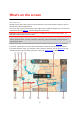
What's on the screen The map view The map view is shown when you have no planned route. Your actual location is shown as soon as your VIA has found your GPS location. You can use map view in the same way as you might look at a traditional paper map. You can move around the map using gestures, and zoom using the zoom buttons.
1. Back button. This button returns the map to an overview of your whole route or, if no route is planned, moves the map to put your current location at the center. 2. Switch view button. Select the switch view button to change between the map view and the guidance view. When in map view, if you are driving, the small arrow rotates to indicate your direction of travel relative to north, with north being up.
9. Your route, if you have planned a route. Select the route to clear it, change the route type, add a stop or save changes to your route. 10. Safety cameras on your route. Select a safety camera to display information about that camera. 11. Route bar. The route bar is shown when you have planned a route. The guidance view The guidance view is used to guide you along the route to your destination. The guidance view is shown when you start driving.
Tip: The compass direction you are driving is shown in the switch view button below the small compass arrow, for example, NE for North East. These compass directions automatically appear when driving in North America and disappear if you leave North America. 2. Zoom buttons. Select the zoom buttons to zoom in and out. Tip: On some devices you can also pinch to zoom in and out. 3. Instruction panel. This panel shows the following information: The direction of your next turn.
The arrival information panel shows the following information: Tip: If your destination is in a different time zone, you see a plus (+) or a minus (-) sign and the time difference in hours and half hours in the arrival information panel. The estimated time of arrival is the local time at your destination. The estimated time that you will arrive at your destination. The length of time to drive to the destination from your current location.
For remaining distances longer than 31 miles (50 km), only the next 31 miles (50 km) is shown. The destination icon is not shown. Tip: You can scroll the route bar to see your whole route (not available on iOS). For remaining distances between 6 miles (10 km) and 31 miles (50 km), the complete distance is shown. The destination icon is shown fixed at the top of the route bar. For remaining distances of less than 6 miles (10 km) the complete distance is shown.
Point of Interest Latitude Longitude In the Drive To menu, select this button to search for a point of interest, then plan a route to that location. In the Drive To menu, select this button to search for a latitude-longitude coordinate, then plan a route to that location. Drive Home Select this button to drive to your home location. If this button is not included in your main menu, go to My Places to set up your home location. Drive to Work Select this button to drive to your work location.
My Routes Parking Gas Station Start Recording Select this button to show your saved routes. Select this button to find parking lots/garages. Select this button to find gas stations. Select this button to start or stop recording a track. Main Menu smaller buttons and symbols On the map or guidance view, select the Main Menu button to open the Main Menu. The following buttons are available in the Main Menu screen, in addition to the navigation buttons: Select this button to open the Settings Menu.
Select this button to return to the map view or guidance view. This symbol shows the power level of the battery in your device. This symbol shows that your VIA is connected to your TomTom account. This symbol shows that your VIA is not connected to your TomTom account. This button shows that you will hear voice instructions. Select this button to switch off voice instructions.
Select and slide the volume control to change the volume of voice instructions and warnings. If the voice instructions are turned off, the volume control will still change the volume of the warnings. Using gestures You use gestures to control your VIA. In this User Manual, you learn how to use gestures to control your VIA. Below is an explanation of each gesture. Double tap Touch one finger on the screen twice in rapid succession. Example of when to use this: Zooming in on the map.
Changing the text and button size You can change the size of the text and the buttons you see on the screen, for example to make the text easier to read and the buttons easier to use. Note: This feature is only available on devices with a 6 inch / 15 cm or larger screen. To change the size of the text and the buttons, select the Settings button in the Main Menu, then select Appearance, then select Size of text and buttons. Your device must restart to apply the change.
Traffic About RDS-TMC The Traffic Message Channel (TMC), also known as RDS-TMC, transmits traffic information as a radio signal and is available free of charge in many countries. TMC is not a TomTom service, but is available when using the TomTom RDS-TMC Traffic Receiver. Note: TMC is not available in all countries. To check the availability of TMC services in your country, go to tomtom.com/5826. TomTom is not responsible for the availability or quality of traffic information provided by TMC.
For a complete list of incident types, see Traffic incidents. 2. Traffic incident on your route but in the opposite direction of travel. 3. Traffic incidents on roads that are not visible at your current zoom level. Looking at traffic on your route Information about traffic incidents on your route is shown in the route bar on the right-hand side of the map and guidance views.
Road closure Rain Fog Ice or snow Wind The symbol or number at the start of the incident shows the type of incident or the delay in minutes, for example 4 minutes. The color of the incident indicates the speed of traffic relative to the maximum allowed speed at that location, with red being the slowest. The stripes on the traffic jam are also animated to show the speed of the traffic, where appropriate.
To change the way you are warned, select Sounds & Warnings in the Settings menu. Avoiding a traffic jam on your route You can avoid a traffic jam that is on your route. Note: Sometimes the quickest route is still the route that has the traffic jam. Note: It may not be possible to find an alternative route around the traffic jam if none exists. Avoiding a traffic jam using the route bar 1. In the route bar, select the symbol for the traffic jam you want to avoid. The traffic jam is shown on the map. 2.
To get more information about the faster route, select the decision symbol in the route bar. The map opens zoomed in on the location where you have to take the new route. Advanced Lane Guidance Note: Lane guidance is not available for all intersections or in all countries. Advanced Lane Guidance helps you prepare for highway exits and junctions by showing the correct driving lane for your planned route. As you approach an exit or junction, the lane you need is shown on the screen.
Important: The speed limit shown in the speed panel is only an indication. You must always obey the actual speed limit for the road you are on and the conditions you are driving in.
Syncing using TomTom MyDrive About TomTom MyDrive TomTom MyDrive is the easy way to import community POI files on your TomTom VIA. Logging into your TomTom account You must log into MyDrive to sync to your TomTom account. When you log into your TomTom account from your navigation device or when using a web browser, syncing with your account happens automatically. Logging into MyDrive on your VIA 1. Connect your VIA to your computer using MyDrive Connect. 2.
Importing a community POI list - MyDrive - NOT CONNECTED You can find collections of community POIs on the Internet and upload them to My Places using MyDrive in a web browser. A POI collection might contain, for example, campsites or restaurants for the area you are traveling in, and provides an easy way to select a location without the need to search for the location each time. Your VIA uses .OV2 files for POI collections. To upload an .OV2 file to your VIA, do the following: 1.
1. Connect your VIA to your computer using MyDrive Connect. 2. In MyDrive, select My Routes. 3. Select Import a GPX File and browse to your .GPX track file. Tip: The name of the track file in My Routes will be the same as the name of the .GPX file. Edit the name of the file so that you can easily recognize it in My Routes. Your new track is shown in the My Routes list. 4. Wait for the track file to upload to your VIA. 5. Open My Routes. Your imported track is shown in your My Routes list.
Step by step search Using step-by-step search About search STEP-BY-STEP SEARCH ONLY You use the Drive To menu to find addresses and Points of Interest (POI) and then navigate to them. You must first choose the country or state you want to search in, then enter the address or the POI type or name. In Address, you can search for the following: A specific address in a town or city. A ZIP code, for example, type in 36925 York for York, Alabama.
Select this button to go back to the previous screen. 2. Search input box Enter your search term here. As you type, matching addresses or POIs are shown. Tip: If you press and hold a letter key on the keyboard, you get access to extra characters if they are available. For example, press and hold the letter "e" to access characters 3 e è é ê ë and more. Tip: To edit, select a word you have already typed to place the cursor. You can then insert or delete characters. 3.
When you select an address from the list of search results, you can choose to show it on the map, add a crossroad, or plan a route to that chosen location. To get an exact address you can add the house number. When you select a POI from the list of search results, it is shown on the map. When you show the address or POI on the map, you can use the pop-up menu to add the location to My Places. If a route is already planned, you can add the location to your current route.
Court house ATM Legal - Attorneys Bank Legal - other services Food services Convenience store Fast food restaurant Restaurant Chinese restaurant Accommodation Hotel or motel Luxury hotel Campground Economy chain hotel Emergency services Hospital or clinic Dentist Police station Veterinarian Doctor Fire station Car-related services Outside parking Gas station Parking garage Car wash Car dealer Vehicle inspection center 33
Rental car facility Electric/hybrid car charging point(s) Rental car parking Car repair facility Other services Embassy Pet services Government office Telecommunication Company Community service Post office Pharmacy Shopping center Beauty services Tourist information office Shop College or university School Library Convention center Casino Winery Theater Tourist attraction Movie Theater Zoo Education Leisure 34
Concert hall Amusement park Museum Exhibition center Opera Cultural center Nightlife Leisure center Children's Farm Sport Sports Park Swimming pool Mountain peak Water sports Beach Tennis court Park or recreation area Ice skating rink Yacht basin or marina Sports center Stadium Golf course Church Place of worship Railroad station Mountain pass Religion Travel 35
Airport Scenic or panoramic view Ferry terminal ZIP code Note: Not used in all countries.
If your device prompts "Going to X?," where X is a destination, you have 12 seconds to respond yes or no. Tip: If you don't respond yes or no, your VIA assumes a yes. To respond yes, say "Yes" or select Yes. Your device plans a route to your destination. To respond no, say "No", select No, or tap the screen to return to the map. Switching destination prediction on or off You can turn destination prediction on or off at any time.
When the correct street name appears in the list, select the name. 6. Enter the house number. Tip: If the house number does not exist then it appears red. The nearest house number is then shown in the Drive to button. 7. Select Drive/Ride, depending on which device you are using. A route is planned and then guidance to your destination begins. As soon as you start driving, the guidance view is shown automatically.
2. Select Drive To. 3. Select Address. You can change the country or state setting by selecting the flag before you select a city. 4. Enter the town or city name. Towns with similar names are shown in the list while you type. When the correct city or town appears in the list, select the name. 5. Select the city center POI. 6. Select Drive/Ride, depending on which device you are using.
A route is planned and then guidance to your destination begins. As soon as you start driving, the guidance view is shown automatically. Tip: If your destination is in a different time zone, you see a plus (+) or a minus (-) sign and the time difference in hours and half hours in the arrival information panel. The estimated time of arrival is the local time at your destination. Tip: You can add a stop to a route that you have already planned. Tip: You can save a route using My Routes.
As you type, suggestions based on what you have entered are shown. 6. Select a POI type or an individual POI. If you selected a POI type, select a POI. The location is shown on the map. 7. To see more information about the POI, select the POI on the map and then select the pop-up menu button. Select More Information on the pop-up menu. You see more information about the POI such as the phone number, full address, and email. 8.
1. Move the map and zoom in until you can see the destination that you want to navigate to. Tip: You can also select a map symbol to open the pop-up menu, then select the Drive/Ride button to plan a route to that location. 2. When you have found your destination on the map, select it by pressing and holding the screen for about one second. A pop-up menu shows the nearest address. 3. To plan a route to this destination, select Drive/Ride, depending on which device you are using.
Tip: If your destination is in a different time zone, you see a plus (+) or a minus (-) sign and the time difference in hours and half hours in the arrival information panel. The estimated time of arrival is the local time at your destination. Tip: You can add a stop to a route that you have already planned. Tip: You can save a route using My Routes. Planning a route using My Places To navigate to one of My Places from your current location, do the following: 1.
Tip: If your destination is in a different time zone, you see a plus (+) or a minus (-) sign and the time difference in hours and half hours in the arrival information panel. The estimated time of arrival is the local time at your destination. Tip: You can add a stop to a route that you have already planned. Tip: You can save a route using My Routes.
6. Select a suggestion for your destination. The location is shown on the map. 7. To plan a route to this destination, select Drive/Ride, depending on which device you are using. A route is planned and then guidance to your destination begins. As soon as you start driving, the guidance view is shown automatically. Tip: If your destination is in a different time zone, you see a plus (+) or a minus (-) sign and the time difference in hours and half hours in the arrival information panel.
A pop-up menu shows a list of options. 3. Select Remove Starting Point. Your route is replanned with your current location as the starting point. The original starting point is removed from your route. Changing the starting point into a stop 1. Select the starting point on the route in the map view. 2. Select the pop-up menu button. A pop-up menu shows a list of options. 3. Select Change to a Stop. Your route is replanned with the starting point changed into a stop.
2. Select Parking. The map opens showing the locations of parking lots. If a route is planned, the map shows parking lots near your destination. If a route isn't planned, the map shows parking lots near your current location. You can change the screen to show a list of parking lots by pressing this button: You can select a parking lot from the list to locate it on the map. Tip: You can scroll down the list of results using the scroll bar on the right side of the screen.
If you want to change how the search is done, select the button to the right of the search box. You can then change where the search is carried out, for example, to search near you or the whole map. 3. Select a parking lot from the map or the list. A pop-up menu opens on the map showing the name of the parking lot. 4. Select Drive/Ride, depending on which device you are using. A route is planned and then guidance to your destination begins.
The map opens showing the locations of gas stations. If a route is planned, the map shows gas stations along your route. If a route isn't planned, the map shows gas stations near your current location. You can change the screen to show a list of gas stations by pressing this button: You can select a gas station from the list to locate it on the map. Tip: You can scroll down the list of results using the scroll bar on the right side of the screen.
A pop-up menu opens on the map showing the name of the gas station. 4. Select Drive/Ride, depending on which device you are using. A route is planned and then guidance to your destination begins. As soon as you start driving, the guidance view is shown automatically. Tip: You can add a gas station as a stop on your route by using the pop-up menu. A gas station that is a stop on your route has a blue icon.
Changing your route The Current Route menu When you have planned a route or track, select the Current Route or Current Track button in the Main Menu to open the Current Route or Current Track Menu. The following buttons are available in the menu: Clear Route / Clear Track Skip Next Stop Find Alternative Select this button to clear the currently planned route or track. The Current Route Menu closes and you return to the map view. Select this button to skip the next stop on your route.
Show Instructions Select this button to see a list of turn-by-turn text instructions for your planned route. The instructions include the following: Your current location. Street names. Up to two road numbers shown in road signs whenever available. An instruction arrow. An instruction description. The distance between two consecutive instructions. Exit number. The full addresses of stops on your route. Tip: Select an instruction to see a preview of that section of the route in the map view.
Drive to Route or Track Select Drive to Route to plan a route from your current location to the starting point of a My Route. The starting point is converted to a stop. Drive to Track plans a route to the nearest point of the track from your current position. Drive to Starting Point Share Track On the Current Track menu, select this button to plan a route to the starting point of the track. The starting point is converted to a stop. For more information, see Navigating using a track.
1. Select the Main Menu button to open the Main Menu. 2. Select Current Route. 3. Select Avoid Part of Route. A screen opens showing a list of the sections that comprise your current route. 4. Select the section of the route that you want to avoid. A preview shows you the section you have chosen on the map. 5. Select Avoid. A new route is found that avoids your chosen route section. The new route is shown on the map view.
Up to three alternative routes are shown on the map view. Each alternative route shows the difference in travel time in a balloon. You can also select the km/mi button to show the difference as a distance. 5. Select your chosen route by tapping on the time balloon. 6. Select Let's go. 7. Guidance to your destination begins. As soon as you start driving, the guidance view is shown automatically.
If you choose to avoid a route feature, a new route is planned. In Route Planning in the Settings Menu, you can set how each route feature is handled when a new route is planned. To avoid a feature on your route, do the following. 1. Select the Main Menu button to open the Main Menu. 2. Select Current Route. 3. Select Avoid toll roads and More. A screen opens showing a list of the features you can avoid. The features found on your route are highlighted. 4. Select feature that you want to avoid. 5.
Zoom in on the map, then press and hold to select a location. In the pop-up menu, select Add. Select Search and search for a location. When you have found a location, select Add. Your route is recalculated to include your stop. Adding a stop to your route using the map 1. Press the switch view button to show the map. Your complete route is shown on the map. 2. Zoom in on the map, then press and hold to select a location. 3. Select the pop-up menu button. 4. Select Use in Route. 5.
My Routes About My Routes My Routes provides an easy way to save and retrieve routes and tracks. You may want to use My Routes in one or more of the following situations: While working - Your job involves driving several routes with multiple stops on a daily basis. Your routes can change and you need to be flexible and be able to change the order of your stops or change the planned route. While on vacation - You are going on vacation and want to plan and save a route.
Using GPX files There are several things you can do with your GPX file: Use a tool such as Tyre Pro to view your track file. Export to a memory card or directly to your computer, then use your computer to view the file using software such as Google Earth. Note: While viewing your recording, you may notice that the recorded GPS locations do not always correspond with the roads. This can happen for several reasons.
5. Edit the name of the route so that you can easily recognize it. 6. Save your route in the My Routes list. Tip: You can also save a route using the Add to My Routes button in the Current Route menu. Navigating using a saved route To navigate using a previously saved route, do the following: 1. In the Main Menu, select My Routes. 2. Select a route from your list. The route is shown on the map view. 3. To navigate to the start of the saved route, select Drive/Ride depending on which device you are using.
Note: The route from the original starting point up to the new starting point is removed from the route. Note: Your original route in My Routes is not changed. If you want to see the whole route, select the route again in My Routes. 1. In the Main Menu, select My Routes. 2. Select a route from your list. The route is shown on the map view. 3. Select the stop that you want to use as your starting point, then select the pop-up menu button to open the menu. 4. Select Start Route From Here.
The starting point of your route is converted to your first stop and then the route is planned from your current location. Guidance to your destination begins. As soon as you start driving, the guidance view is shown automatically. Tip: There are two other ways to navigate using a saved route: Select the starting point of the route. When the pop-up menu opens, select Change to a Stop. Alternatively, select Drive to Route or Ride to Route in the Current Route menu.
Tip: To update the saved route in your My Routes list with the changes, select the route on the map, then select Save Changes to Route in the pop-up menu. Recording a track You can record a track while you drive, with or without a route planned. After recording, you can then export your track so that you can share it with others or view it using tools such as Tyre Pro. To record a track, do the following: 1. In the Main Menu, select Start Recording.
3. Select the track, then select the pop-up menu. 4. Select Drive to Starting Point. The starting point of the track is converted to your first stop and then the route is planned. Guidance to your destination begins from your current location. As soon as you start driving, the guidance view is shown automatically. Note: You see two different colours on the map for your route and track. You see one color for the route from your current location to the starting point and another second color for the track.
Tip: If there is not enough space on your memory card or your card is not formatted correctly, you get on-screen help to fix the problem. 5. When you see a message that your tracks have been exported successfully, remove your memory card to share your tracks with other users. Note: Each exported route is saved as a GPX file in the TomTom Routes folder on your memory card.
Map Share About Map Share You can report map changes using Map Share. These map changes are then shared with other TomTom device users when they receive a map update. There are two ways to report a map change: Select a location on the map and create the change report immediately. Mark a location and create the change report later. To send your map change reports to TomTom, you must connect your VIA to your computer and use MyDrive Connect. All map changes are verified by TomTom.
Note: If you want to report a map change of a type not shown in the menu, use the Map Share Reporter at tomtom.com. 5. Follow the instructions for your chosen type of map change. 6. Select Report. 7. Connect your VIA to MyDrive Connect to send your map change report to TomTom and receive map changes from other TomTom users. Creating a map change report from a marked location If you see a map inconsistency while you are driving, you can mark the location so you can report the change later.
Note: If you want to report a map change of a type not shown in the menu, use the Map Share Reporter at tomtom.com. 7. Follow the instructions for your chosen type of map change. 8. Select Report. The marker for the marked location is removed from the map. 9. Connect your VIA to MyDrive Connect to send your map change report to TomTom and receive map changes from other TomTom users. Types of map change There are several types of map change available.
Turn Restriction Select this option to report incorrect road turn restrictions. 1. 2. 3. 4. 5. 6. Press and hold to select the location of the map change on the map view. Select the pop-up menu button to open the menu. Select Report Map Change from the pop-up menu. Select Turn Restriction. If the incorrect intersection is shown, choose Select another intersection. Select the approach direction. The map rotates so that the direction you are coming from is shown at the bottom of the screen. 7.
Safety Cameras About safety cameras The Safety Cameras service warns you about the following camera locations: Fixed safety camera locations. Average safety camera locations. Speed enforcement zones. Red light camera locations. Traffic restriction cameras. The Safety Cameras service also warns you about the following safety hazards: Accident blackspot locations. Note: Your new TomTom VIA comes pre-loaded with safety camera locations.
Symbol shown on map Symbol shown in route bar Description Average speed safety cameras - these types of cameras measure your average speed between two points. You are warned at the start and end of the average speed zone. While you are driving in an average speed zone, your average speed is shown, instead of your current speed. The distance to the end of the area is shown in the route bar. Speed enforcement zones - these zones can contain multiple safety cameras.
Updating locations for cameras and hazards The locations of safety cameras can change frequently. New cameras can also appear without warning and the locations for other hazards, such as accident hotspots, may also change. Your new TomTom VIA comes pre-loaded with safety camera locations. To keep these camera and hazard locations up to date, connect your VIA to TomTom MyDrive frequently.
My Places About My Places My Places provides an easy way to select a location without the need to search for the location each time. You can use My Places to create a collection of useful or favorite addresses. Tip: The terms "favorite" and "place" mean the same thing - favorites are places that you go to often. The following items are always in My Places: Home - Your home location can be your home address or somewhere you often visit. This feature provides an easy way to navigate there.
Zoom in on the map at the location you want to select. Press and hold to select the location, then select Set. Select the Search button and search for a location. Select a location to set as home or work, then select Set. Setting your home or work location using the map 1. In the Map View, move the map and zoom in until you can see your home or work location. 2. Press and hold to select the location. A pop-up menu shows the nearest address. 1. Open the pop-up menu and select Add to My Places. 2.
3. Select Add. Your home location is changed to the new location. Adding a location from My Places 1. In the Main Menu, select My Places. 2. Select Add a new place. 3. To select a location, do one of the following: Zoom in on the map at the location you want to select. Press and hold to select the location, then select the add location symbol. Search for a location. Select Show on Map, then select the add location symbol. The name of the location appears in the edit screen. 4.
3. When the map view shows the location, select the pop-up menu button. 4. Select Add to My Places. The name of the location appears in the edit screen. 5. Edit the name of the location so you can easily recognize it. 6. Select Done to save your location in the My Places list. Adding a location to My Places by marking To mark a location and temporarily add it to My Places, do the following: 1. Make sure that your current location is the location you want to mark. 2.
Note: Your VIA needs at least 400 MB free space before it can import .OV2 and .GPX files. If you see the message You need more space, make space available by deleting unwanted .OV2 or .GPX files using MyDrive or deleting device content, for example delete a map you don't use. Using an .OV2 file on your VIA 1. Upload the .OV2 file using MyDrive in a browser. 2. Select My Places in the Main Menu. Your new POI list is shown in the Places list. 3. Select your new POI list.
Settings Appearance Select Settings in the Main Menu, then select Appearance. On this screen, you can change these settings: Display Select Display to change the appearance of the display. Route bar Select Route bar to change the information you see in the route bar. Guidance view Select Guidance view to change the information you see in the guidance view. Automatic zoom Select Automatic Zoom to change how you view an intersection as you drive.
Brightness Select Brightness to change the following settings: Day brightness Move the slider to adjust the brightness level of the screen during the day. Night brightness Move the slider to adjust the brightness level of the screen during the night. Select Switch to night colors when dark to automatically switch to night colors when it gets dark. Size of text and buttons Select Size of text and buttons to change the size of the text and the buttons you see on the screen.
When the wide route bar is shown, you see more information about your route. For example, you see time and distance to traffic and more. Guidance view Select Settings in the Main Menu, then select Appearance. Show current street name This setting displays name of the street you are driving along. Guidance view style Select this setting to choose from 3D or 2D versions of the guidance view. Both the 2D and 3D guidance views move in your direction of travel.
Highway exit previews Select Settings in the Main Menu, then select Appearance. Select Highway exit previews to change settings for the Guidance view as you approach highway exits or junctions. Show map and preview A split screen is shown with the Guidance view on the left and lane guidance on the right. Show preview only Only lane guidance is shown. Off Only the Guidance view is shown. Route Planning Select Settings in the Main Menu, then select Route Planning.
Note: Winding route is not available on all TomTom navigation devices or apps. Avoid interstate highways - this type of route avoids all highways. Walking route - a route designed for making the trip on foot. Bicycle route - a route designed for making the trip on a bicycle. Avoid on every route You can choose to avoid ferries and car shuttle trains, toll roads, carpool lanes, and unpaved roads. Set how your VIA should manage each of these road features when the device calculates a route.
Warnings You can set how you want to be warned for different types of cameras, danger zones, and safety hazards. You can choose to be always warned, warned only if you are speeding, or never warned. Safety Cameras & hazards You can choose to switch off all safety camera, danger zone, and hazard warnings. When Safety Cameras & hazards is switched on, you can switch off the warnings for each type of safety camera, danger zone, and hazard.
Read road sign information out loud Use this setting to control whether road sign information is read out loud as part of navigation instructions. For example, "Turn left onto A302 Bridge Street towards Islington." Read street names out loud Use this setting to control whether street names are read out loud as part of navigation instructions. For example, when street names are read out loud, you hear "Turn left Graham Road towards Hackney.
About This screen shows you all sorts of useful information about your model of TomTom device. This information is useful during calls to Customer Support and when renewing subscriptions using the TomTom web shop. Some of the information shown here includes: Your service subscriptions - select a service to see how long you have left before your subscription expires. Serial number. Installed maps. Free memory space.
Getting Help Help Select Help from the Main Menu or the Settings menu. On this screen, you can see the following information: Guided tour Select this option to get a short tutorial on how to use your navigation device, if supported by your device. About See System. More help You can get further help by going to tomtom.com/support. For warranty and privacy information, go to tomtom.com/legal.
Product certification Finding product certification information on your device To find product certification information, such as the ICASA-approved certification number, do the following on your VIA: 1. Select Settings in the Main Menu. 2. Select System. 3. 4. 5. 6. Select About. Select Legal information. Select Certificates. You then see the relevant product certification information for your VIA, for example, ICASA.
Updating using MyDrive Connect About MyDrive Connect MyDrive Connect is a desktop-based application that helps you manage the content and services of your TomTom VIA. For example, you can use MyDrive Connect to get map updates, software updates or manage your TomTom account. You can also manage your the devices associated with your account using MyDrive Connect. Note: You can associate up to ten TomTom devices with one TomTom account.
Note: For devices with a separate mount, you cannot use the mount to connect your VIA to your computer. Note: You should plug the USB cable directly into a USB port on your computer and not into a USB hub or USB port on a keyboard or monitor. 5. Enter the requested information for account creation, including your country. When setup is complete, a TomTom account is created and your VIA is linked to that account. You can now access MyDrive Connect from the notification area on your desktop.
TomTom account To download content and to use TomTom services, you need a TomTom account. You can create an account using your computer in one of the following ways: By selecting the Create account button at tomtom.com. By selecting the green MyTomTom button at tomtom.com. By going to tomtom.com/getstarted. Important: Take care when choosing a country during account creation.
Addendum Important Safety Notices and Warnings Global Positioning System (GPS) and Global Navigation Satellite System (GLONASS) The Global Positioning System (GPS) and Global Navigation Satellite System (GLONASS) systems are satellite-based systems that provide location and timing information around the globe. GPS is operated and controlled by the Government of the United States of America, which is solely responsible for its availability and accuracy.
Most accidents happen less than 5 km / 3 miles from home. Obey the rules of the road. Always use your turn signals. Every 2 hours, take a break for at least 10 minutes. Keep your seat belts on. Keep a safe distance from the vehicle in front. Before setting off on a motorcycle, fasten your helmet correctly. When riding a motorcycle, always wear protective clothing and equipment. When riding a motorcycle, be extra vigilant and always ride defensively.
Device battery (Non-replaceable) This product contains a lithium polymer battery. Do not modify or re-manufacture the battery. Do not attempt to insert foreign objects into the battery, or immerse or expose to water or other liquids. Do not expose the battery to fire, explosion, or other hazard. Do not short circuit a battery or allow metallic conductive objects to contact battery terminals.
This GPS Navigation System is a radio transmitter and receiver. It is designed and manufactured not to exceed the emission limits for exposure to radio frequency (RF) energy set by the Federal Communications Commission (FCC) of the U.S. Government, Industry Canada of the Canadian Government (IC). The SAR limit recommended by the Federal Communications Commission (FCC) of the U.S. Government, Industry Canada of the Canadian Government (IC) is 1.6W/kg averaged over 1 gram of tissue for the body (4.
Emissions information for Canada Operation is subject to the following two conditions: This device may not cause interference. This device must accept any interference, including interference that may cause undesired operation of the device. Operation is subject to the condition that this device does not cause harmful interference. This Class B digital apparatus complies with Canadian ICES-003.
Model numbers 4AA43, 4AA53, 4AA63 Accessories supplied with this device Adhesive disk USB cable RDS-TMC cable Quick Start Guide 96
Copyright notices © 1992 - 2017 TomTom. All rights reserved. TomTom and the "two hands" logo are trademarks or registered trademarks of TomTom N.V. or one of its subsidiaries. Please see tomtom.com/legal for limited warranty and end user license agreements applying to this product. © 1992 - 2017 TomTom. All rights reserved. This material is proprietary and the subject of copyright protection and/or database rights protection and/or other intellectual property rights owned by TomTom or its suppliers.