
User Manual


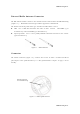
Table Of Contents
HiPerII Chapter 1
GNSS Overview
Currently, the following two global navigation satellite systems ( GNSS ) offer line-of-site radio
navigation and positioning, velocity, and time services on a global, all-weather scale to any user
equipped with a GNSS tracking receiver on or near the Earth's surface:
GPS - the Global Positioning System maintained and operated by the United States
Department of Defense. For information on the status of this system, visit the US Naval
Observatory website ( http://tycho.usno.navy.mil/ ) or the US Coast Guard website
( http://www.navcen.uscg.gov/ ).
GLONASS - the Global Navigation Satellite System maintained and operated by the Russian
Federation Ministry of Defense. For information on the status of this system, visit the
Coordinational Scientific In-formation Center website ( http://www.glonass-ianc.rsa.ru/ ).
Despite numerous technical differences in the implementation of these systems, satellite
positioning systems have three essential components:
Space - GPS and GLONASS satellites orbit approximately 12,000 nautical miles above Earth
and are equipped with a clock and radio. These satellites broadcast ranging signals and
various digital information ( ephemerides, almanacs, time and frequency corrections, and
so forth ).
Control - Ground stations located around the Earth that monitor the satellites and upload
data, including clock corrections and new ephemerides ( satellite positions as a function of
time ), to ensure the satellites transmit data properly.
User - The community and military that use GNSS receivers to calculate positions.
Calculating Absolute Positions
When calculating an absolute position, a stationary or moving receiver determines its
three-dimensional position with respect to the origin of an Earth-Center Earth-Fixed coordinate
system. To calculate this position, the receiver measures the distance ( called pseudo-ranges )
between it and at least four satellites.
The measured pseudo- ranges are corrected for clock differences ( receiver and satellites ) and
signal propagation delays due to atmospheric effects. The positions of the satellites are
computed from the ephemeris data transmitted to the receiver in navigation messages. When
using a single satellite system, the minimum number of satellites needed to compute a position
is four. In a mixed satellite scenario ( GPS, GLONASS ), the receiver must lock onto five or
more satellites to account for the different time scales used in these systems and to obtain an
absolute position.
HiPerII Chapter 1