
User's Manual


3
• Availability – The availability of satellites affects the calculation of valid positions. The more visible satellites
available, the more valid and accurate the position. Natural and man-made objects can block, interrupt, and
distort signals, lowering the number of available satellites and adversely affecting signal reception.
• Integrity – Fault tolerance allows a position to have greater integrity, increasing accuracy. Several factors
combine to provide fault tolerance, including:
– Receiver Autonomous Integrity Monitoring (RAIM) detects faulty GPS and GLONASS satellites and
removes them from the position calculation.
– Five or more visible satellites for only GPS or only GLONASS; six or more satellites for mixed scenarios.
– Wide Area Augmentation Systems (WAAS, EGNOS, etc.) creates and transmit, along with DGPS
corrections, data integrity information (for example, satellite health warnings).
– Current ephemerides and almanacs.
Conclusion
This overview simply outlines the basics of satellite positioning. For more detailed information, visit the TPS
website.
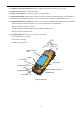
GRS Overview
The GRS is a fully integrated hand-held controller and GPS+ receiver. Included in the system is an electronic
compass and digital camera.
The hand-held controller component of the GRS
includes the Windows® Mobile operating system and color LCD touch screen. Integrated Bluetooth® /Cell phone
modem (option)wireless technology allows this system to be a cable-free controller/receiver for maximum
portability. The rugged casing is durable and built for rugged use.
As a field controller, the GRS can run a full suite of field software for working with total stations and RTK GPS
systems.
The GPS+ receiver component of the GRS
can receive and process GPS+GLONASS L1/L2 signals improving the accuracy of your survey points and positions.
The GPS+ features of the receiver combine to provide a positioning system accurate for any survey. Several other
features, including multipath mitigation, provide under-canopy and low signal strength reception.
When power is turned on and the receiver self-test completes, the receiver’s 50 channels initialize and begin
tracking visible satellites. Each of the receiver’s channels can be used to track any one of the GPS or GLONASS
signals. The number of channels available allows the receiver to track all visible GPS satellites at any time and
location.
An internal GPS antenna equipped with a low noise amplifier (LNA) and the receiver’s radio frequency (RF) device
are connected with a coaxial cable. The wide-band signal received is down-converted, filtered, digitized, and
assigned to different channels. The receiver processor controls the process of signal tracking.
Once the signal is locked in the channel, it is demodulated and necessary signal parameters (carrier and code phases)
are measured. Also, broadcast navigation data are retrieved from the navigation frame.
After the receiver locks on to four or more satellites, it is possible to solve the so-called “absolute positioning
problem” and compute the receiver’s coordinates (in WGS-84) and the time offset between the receiver clock and
GPS time. All this information can be stored in the the optional SD card and internal flash memory, then processed
using a post-processing software package.
Capabilities of the GRS receiver include: