Perspective -- Navigation Processing Guide -Software Version 7.6 By: Tony M.
Triton Imaging Inc. Engineering Office 2121 41st Avenue, Suite 211 Capitola, CA 95010 USA 831-722-7373 831-475-8446 sales@tritonimaginginc.com support@tritonimaginginc.com © 2013 TRITON This user guide is provided as a means to become familiar with TRITON’s software through an explanation of the options available for processing navigation data. The user interface presented in this guide is subject to change to accommodate software upgrades and revisions.
Table of Contents 1.0 Navigation Types ................................................................................ 1 2.0 Processing Options ............................................................................... 2 2.1 File Tree Processing .......................................................................................................................................... 2 2.1.1 Beamlines........................................................................................................
Navigation Processing Processing navigation is an important step to obtaining clean results and some thought should go into what parameters to use and what level of processing is necessary for the collected data. Discussed in the following sections are how Perspective sorts and displays the navigation data from imported raw data files, reasons to process navigation prior to creating mosaics or DTMs, available options for navigation processing, and possible workflows.
2.0 Processing Options 2.1 File Tree Processing One way to process navigation data is from the Navigation file tree. Once data files have been imported and the navigation sorted into the file tree sections, navigation processing can be accomplished be right-clicking on either an individual file or on the root file tree node for each data type. However, before launching the navigation processing dialog, it is often helpful to turn on "beamlines". 2.1.
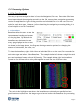
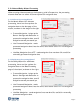
The image right shows a good zoom level for monitoring the effects of navigation processing on the beamlines. Note in this image that beamlines are not only good for monitoring navigation processing but also for viewing line overlap. 2.1.2 Process Navigation Dialog For processing navigation from the File Tree, select the Process Navigation option available by right-clicking on any tree level in the Navigation layer. Selecting this will launch the dialog shown right.
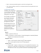
Reset - Overwrites processed navigation in cache with raw navigation data. Exit - Saves processing to cache file if not already done with the auto update option, exits processing wizard. 2.1.3 Filter Boxcar Settings Clicking on Filter Setup in the Process Navigation dialog will open the boxcar filter setting dialog shown to the right. In this dialog it is possible to set the size of the boxcar filter, the source of the navigation and heading data, plus speed filter options.
Bias - apply a single bias to the computed CMG heading Change Cutoff - cutoff value for CMG calculation (in degrees) Sensor - uses the heading found in the XTF sensor navigation Ship - uses the heading found in the XTF ship navigation Speed Filter Speed - the checkbox turns the option on Min - enter the minimum expected speed Max - enter the maximum expected speed Change Cutoff - cutoff value for speed filter (in knots) Compute Never - use the speed from the XTF file Always - ign
2.2 Sidescan/Bathy Wizard Processing When creating sidescan mosaics or bathymetry grids in Perspective, the processing wizards allow users to select different options for navigation data. 2.2.1 Sidescan Processing Wizard In the Mosaic Wizard for sidescan processing, there are three options for navigation data on the last page of the wizard, as shown in the image to the right.
Use Precise Timing Architecture - used for data collected with an Applanix POSMV, requires POSRAW packets The same options for processing navigation from the file tree are available in the Mosaic and Bathy wizards, except for the ability to monitor the progress with beamlines. For users familiar with their data that know which navigation processing settings give the best results, monitoring the effects of navigation processing with beamlines is not necessary. 2.
2.4 When and How Much To Process... Below is a discussion on the different processing options for each data type. SIDESCAN: Amount: Sidescan data generally requires multiple passes with the boxcar filter for best results. Often sidescan recording systems have low frequency GPS signals (one update per second) and multiple pings will have the same time stamp.
BATHYMETRY (multibeam, singlebeam, & interferometric data): Amount: Bathymetry data generally requires very little processing of the navigation data. Modern multibeam and singlebeam systems include very precise high frequency GPS data. As long as the vessel position and motion data are properly captured and recorded, then changing the ping location by smoothing the navigation or the instantaneous heading by applying CMG or is not a good idea! For most bathymetry data, just one iteration is enough.
3.0 Processing Workflows 3.1 Process from File Tree (Sidescan, Bathymetry & Subbottom) Upon import of the raw survey data, the navigation can be processed using the Process Navigation dialog available from the File Tree. File Tree Processing Steps: 1. Import Raw Data 2. Select Show Beamlines for at least one of the data files to be processed. 3. Use the Zoom toolbar button to zoom into the Beamlines enough to monitor the processing results 4.
3.2 Process in Wizard (Sidescan & Bathymetry) After raw survey data files have been imported, sidescan data has a TVG curve and good bottom track, bathymetry has SVP and Tide files created, then the processing wizards can be launched for creating sidescan mosaics or bathymetry DTMs. Here is an example workflow for wizard-based navigation processing Processing Steps: 1. Import Raw Data 2.
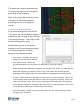
4.0 Bad Navigation Example - Sidescan 4.1 Overview The following example illustrates the need for multiple passes of filtering for sidescan data file. This is an uncommon problem but works well for showing why it is sometimes necessary for repeat processing of the navigation. This data comes from a Klein 5000 sonar which for this survey had a ping rate set faster than the incoming navigation data. It is common for GPS receivers to only receive an update every 1 second while sonar ping rates are much faster.
Based on the ping rate and the vessel speed we expect the beam spacing to be 0.2 meters, not 4.89 meters. By processing the navigation we can smooth the positions of the pings so that the beam lines are parallel and evenly spaced. This is important for getting clean sidescan mosaics without navigation errors impacting the ability to interpret the data. 4.
Creating a sidescan mosaic using the navigation after only one step of navigation filtering shows an obvious striping caused by the unevenly spaced beam lines. This is what processing navigation only within the MosaicOne wizard would have produced for this data file. Files such as this one can clearly benefit from additional navigation processing. 4.
This was after only 2 steps of processing but additional steps may be needed for some data files. Having Beamlines displayed allows the user to immediately see the results of each processing step. 4.
5.0 Bad Navigation Example - Bathymetry 5.1 Overview The following example illustrates the need for multiple passes of filtering for a bathymetry data file. The bad navigation present in this file is due to overhead obstructions and is a common problem when working in harbors and river channels. This data comes from a GeoAcoustics GeoSwath Plus interferrometric sonar and was collected along the Seine River during a demonstration performed by the ECA group of their Inspector USV (unmanned surface vessel).
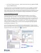
5.2 First Run of Navigation Processing For processing this data I set the WINDOW = 12, NAV SOURCE = SHIP (mounted sonar), ITERATIONS = 1, HEADING = SHIP, SPEED FILTER = 0.5 to 7.0 knots. After only one step of processing the image below shows a relatively smooth line. While this might be adequate for getting good bathymetry processing results, processing the navigation a second time can help remove the remaining sharp bends from the navigation track. 5.
5.4 Compare Results This data example started with very erratic navigation beneath the bridges spanning the river. With repeat navigation processing it was possible to smooth the bad navigation to approximate the true vessel position as it passed under the bridges.