
User guide


10
Chapter 3: Map Tab
Ubiquiti Networks, Inc.
airVision
™
User Guide
Chapter 3: Map Tab
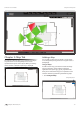
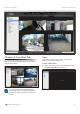
The airVision software allows you to upload map images
of your location or use Google Maps™ for a visual
representation of your camera layout. When you initially
launch airVision, a default sample map is displayed.
Adding a Map
You can add an image you’ve created as a map image
or use Google Maps™ to generate an image for use as a
background.
Image Maps
To add a custom map, you must first create the image
using an illustration, image editing, or blueprint
application that exports .jpg, .gif, or .png file formats.
Once you’ve created the map, you can upload it to the
airVision software by performing the following steps:
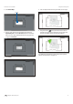
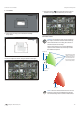
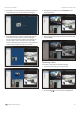
1. Click Configure Maps.
Configure Maps button