TRAX325 In-Car Navigation OWNER’S MANUAL
Contents What Do I Do First? Make sure everything is OK Plug it in 6 6 7 How Do I Put It in My Car? Safety considerations Attaching the windshield mount Adjusting the windshield mount Mounting on the windshield Mounting on a flat surface 8 8 9 10 11 12 How Do I Use It? 14 1: Warnings and Safety Information 14 2: Getting started with TRAX325 Start using TRAX325 Simple and Advanced modes Hardware button (Power on/off) Buttons and other controls on the screen Using keyboards Using the map Check
Returning to normal navigation Selected location (Cursor) Original position in the Cursor menu Daytime and night colour schemes Colour scheme in tunnels Route calculation and recalculation Itinerary Track Logs Route demonstration POI(Points of Interest) Saving POI Managing POI Road Safety Cameras Saving Road Safety Cameras Camera warning Camera types Camera directions Speed limit warning 35 35 36 36 36 37 38 39 39 40 40 40 41 41 41 42 43 44 3:
Creating a multi-point route (inserting a via point) Creating a multi-point route (appending a new destination) Editing the route View the whole route on the map (Fit-to-Screen) Watching the simulation of the route Enabling Safety Mode Pausing the active route Deleting the next via point from the route Deleting the active route Using Track Logs Recording the travelled path (creating a Track Log) Simulating a Track Log on the map Changing the colour of a Track Log Saving a route Loading a saved rout
Route menu Manage menu Manage saved route Manage History Manage Track Logs Manage Favourites Manage POIs Managed Saved Search Criteria User Data management Settings Menu Map Screen settings Sound settings Route Planning options Regional settings Navigation settings Warning settings GPS settings Menu settings Device settings Track Log settings 93 94 95 95 96 97 97 99 100 101 102 103 104 106 107 109 110 111 111 112 5: Glossary 113 What Else Do I Need To
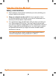
What Do I Do First? Make Sure These Items Arrived in the Box If anything listed here is missing or damaged, contact your place of purchase immediately. TRAX325 GPS Power Power Button button Notch Notchfor forwindshield windshield mount mountbracket bracket. navigation device ►► Press the power button momentarily to turn the screen off (or back on); the device stays on and can still give directions. ►► Press the power button in and hold it for three seconds to turn the device completely off.
What Do I Do First? Included accessories DC DC(car) (car) adapter adapter Adhesive Adhesive anchor anchor disk disk USB cable USB cable Plug it in ►► Connect the power adapter to the power connector on the lower right side of the device. ►► Plug the other end into your car’s cigarette lighter (or any standard 12 V DC outlet). ►► Only use the power adapter that came with your device. Any other adapter might damage the device.
How Do I Put It in My Car? Safety considerations ►► Don’t install any device where it will block your view (including your mirrors!) while you’re driving. ►► Keep your attention on the road! Don’t try to operate or focus on any device while you’re driving. If you have to concentrate on a device, pull off the road for a few minutes. ►► It’s a good idea to take valuable items with you when you leave you car—that includes GPS devices.
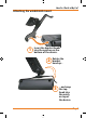
How Do I Put It in My Car? Attaching the windshield mount 1 Insert the bracket hooks into the notches on the bottom of the device. 2 Rotate the bracket head up... 3 ...and snap the top hook into the notch on top of the device.
How Do I Put It in My Car? Adjusting the windshield mount Lift the adjustment lock to move the suction cup and bracket The bracket pivots in all directions ►► The adjustment lock keeps both the bracket and the suction cup locked into place. Lift the adjustment lock to change the position of the device. ►► The suction cup joint pivots front to back, and the bracket joint pivots up, down, right and left, any just about angle in between.
How Do I Put It in My Car? Mounting on the windshield Make sure the device does not block your view of the road or your mirrors. Once you decide where you want the device, hold the suction cup in that position, then adjust the mount so you have the best view of the device. 1) Press the suction cup flat against the windshield. 2) Push the suction lock up (towards the suction cup) until it snaps into place. 3) Gently pull on the mount to make sure it is secure.
How Do I Put It in My Car? Mounting on a flat surface If you want to put the device somewhere other than your windshield (or anywhere the suction cup won’t stick), you can use the anchor disk. Once you glue the anchor disk down, the windshield mount installs inside the disk just like it does on glass. When you’re deciding where to put the anchor disk, here are some things to keep in mind: ►► The surface should be as flat as possible.
How Do I Put It in My Car? 4) Hold the disk exactly above the spot where you want to glue it down. (Remember, the glue is designed to be permanent!) 5) Press the disk firmly against the surface. Push down along the edges, too, so that every part of the disk makes good contact with the surface. 6) Before you install the windshield mount, gently tug on the disk to make sure it’s secure. 7) Remove the clear plastic sheet from the top of the anchor disk.
How Do I Use It? 1: Warnings and Safety information TRAX325 is a navigation system that helps you find your way to your destination with a connected GPS receiver. TRAX325 does not transmit your GPS position; others cannot track you. It is important that you look at the display only when it is safe to do so. If you are the driver of the vehicle, we recommend that you operate TRAX325 before you start your journey. Plan the route before your departure and stop if you need to change something in the route.
How Do I Use It? Tasks Instructions Double tapping You do not need to tap the screen twice for any action. the screen With buttons and controls, a single tap is enough. Tapping and holding the screen You do not need this to access the basic navigation functions. Tap and keep pressing the following buttons to reach extra functions: • Tap and hold on the Map screen: you can set the minimum and maximum zoom level of Smart Zoom.
How Do I Use It? Gestures (drag&drop) You do not need gestures to access the basic navigation features. You need to drag and drop the screen only in cases like: Moving the handle on a slider. Moving the map: grab the map, and move it in the desired direction. Shortcut to open the Map screen: slide your finger from the bottom right corner to the bottom left corner on any screen. Shortcut to open the Navigation menu: slide your finger from the top left corner to the bottom left corner on any screen.
How Do I Use It? The typical way of using TRAX325 is to select a destination, and start navigating. You can select your destination in the following ways (not all of them are available in Simple mode): • Use the selected location on the map (the Cursor) (page 35). • Enter a full address or a part of an address, for example a street name without a house number or the names of two intersecting streets (page 46). • Enter an address with postal code (page 55).
How Do I Use It? Type of action Available in Simple mode Available in Explanation Advanced mode Navigating to a selected map point Yes Yes See page 46 Navigating to a street address Yes Yes See page 46 Navigating to an incomplete address Yes Yes See page 46 Navigating to an intersection Yes Yes See page 52 Navigating to recent destinations (History) Yes Yes See page 59 Navigating to Favourites Yes Yes See page 57 Navigating to a POI Yes Yes See page 57 Navigating to coordinate
How Do I Use It? Route Planning options Yes Yes See page 104 Regional settings Only language selection Yes See page 106 Warnings No Yes See page 109 Hardware button (Power on/off) You can use TRAX325 mostly by tapping the touch screen. The device has only one hardware button for turning power on or off. When the device is on, pressing the power button momentarily turns the LCD screen off (the green LED stays on and the device continues to operate) or on.
How Do I Use It? Icon Shows status information. Some icons also function as a button. Tap them once. List When you need to select from several options, they appear in a list. Turn the page with the and buttons and tap the value that you want. When a feature has several different unnamed values, TRAX325 shows an indicator on a gauge that displays and sets a value from a range. • Drag the handle to move the slider to its new position.
How Do I Use It? Using keyboards You only need to enter letters or numbers in TRAX325 when you cannot avoid it. You can type with your fingertips on the full-screen keyboards and you can switch between various keyboard layouts, for example ABC, QWERTY, or numerical. Task Details Switching to another keyboard layout, for example from a Latin QWERTY keyboard to a Greek keyboard , and select from Tap the list of available keyboard types.
How Do I Use It? Using the map The map screen is the most frequently used screen of TRAX325. It can be accessed from the Navigation menu by tapping . For further information about the map screen, see page 69. Checking the details of a map location • If you are interested in the details of your current position during navigation: 1. Check the bottom line of the map. It shows the current street and house number information. 2. For further details, tap to open the Position menu. .
How Do I Use It? 3. For further details, tap to open the Cursor menu. . The address, the coordinate and the list of 4. Tap nearby POIs will be displayed. • It is even easier if you select the desired point in the Find menu. Then the Cursor menu opens automatically. You only need to button.
How Do I Use It? Opening/ closing map control buttons Tap this button to show or hide the following map control buttons: • Zoom in/out • Rotate left/right (3D map only) • Tilt up/down (3D map only) • Zoom preset buttons (2D map only) • Tilt and zoom preset buttons (3D map only) • Return to GPS position button • Smart Zoom button Zooming in and out Changes how much of the map is displayed on the screen.
How Do I Use It? Rotating left and right Changes the horizontal view angle of the map in 3D mode. When GPS position is available, TRAX325 always rotates the map so its top faces your direction of travel (Track-U p orientation). You can turn away from Track-Up with these buttons. If GPS position is available and you have rotated the map, the button appears. Tap this button to reenable the automatic map rotation.
How Do I Use It? Smart Zoom TRAX325 can automatically rotate, scale and tilt the map and give you the optimal view: • When you are approaching a turn, TRAX325 zooms in and raises the view angle to let you easily recognise your manoeuvre at the next junction. • If the next turn is at a distance, TRAX325 zooms out and lowers the view angle to show you the road in front of you. Tap this button once to enable Smart Zoom. Tap&hold the button to set the zoom limits of Smart Zoom.
How Do I Use It? Tilt and zoom preset buttons (available in Advanced mode only) Tap one of the preset buttons to set the tilt and zoom levels to fix, predefined values. Smart Zoom is disabled. These buttons are available in 3D mode. Map scale TRAX325 shows the scale of the map in 2D mode. Fit-to-screen This button does not appear on the Map screen.
How Do I Use It? There is no active route in Advanced mode If there is no route to be navigated in Advanced mode, this icon appears in the Turn Preview field. Tap this area to open Find. There is no valid If an active route exists, GPS position. and there is no valid GPS position, the view of the sky above you is shown with coloured dots for each satellite. Some dots need to turn green to be able to navigate. Tap this area to open the Route Information screen.
How Do I Use It? Icon Information Details Action There is no valid If there is no valid GPS GPS position position, this symbol appears here. Tap this area to open the GPS Data screen to check the signal status or the connection settings. Traffic restriction When GPS position is available, but there is no route to be navigated, the traffic restriction of the upcoming intersection is shown here if there is any. Nothing happens if you tap this area of the screen.
How Do I Use It? Indicator strip - sounds muted/ enabled Nothing happens if you tap this area of the screen. - Track Log recording - not used - not used The following symbols appear in the Indicator strip: Icon Description The sound output of TRAX325 is muted. The sound output of TRAX325 is enabled. TRAX325 records a Track log when GPS position is available. Track log recording is disabled. The following information can be seen in the three data fields shown on the map screen.
How Do I Use It? Icon Type More Information Compass Shows the direction of your heading both when the map is automatically rotated (3D) and when the map is always facing North (2D).
How Do I Use It? Icon Status for More Information GPS position quality The more lit bars, the better is the GPS position. Battery status The device is running on battery power. The number of lit bars represent the remaining capacity. The battery is being charged The device is running on external power. The battery is being charged. Vehicle type The symbol displays the vehicle type used for route calculation.
How Do I Use It? In the active route, uses the Cursor as the destination while keeping the previous destination as a via point (available in Advanced mode only) Shows the different routes calculated by the available routing methods. Choose the one that suits your needs the best.
How Do I Use It? enable Smart Zoom. Fine-tuning Smart Zoom Tap the map to let the map control buttons appear, and then tap and hold to open the Smart Zoom Settings window. Modify the zoom limits of Smart Zoom if necessary. Position markers Current GPS position and Lock-on-Road When your GPS position is available, TRAX325 marks your current icon on the map. The exact location of the position position with the marker depends on the vehicle type used for route calculation.
How Do I Use It? Return to normal navigation When GPS position is available, and you have moved the map (the icon is moving or is not even visible), or you have rotated the map in 3D button appears. Tap it to move the map back to the GPS mode, the position and re-enable Track-up map orientation (automatic map rotation).
How Do I Use It? Original position in the Cursor menu When the Cursor menu is open, a special icon ( position the menu was opened with. ) shows the Cursor You can move and zoom the map, and you can set the Cursor to a ) appears, and the buttons of the different place. The usual Cursor ( Cursor menu initiate actions for this new location. To return to the original Cursor position, tap . The map jumps back to the position with which the Cursor menu was opened, and the appears again.
How Do I Use It? Route calculation and recalculation TRAX325 calculates the route based on your preferences: • • • Route calculation method: • Fast • Short • Economical • Easy Vehicle types : • Car • Taxi • Bus • Emergency vehicles • Bicycle • Pedestrian Road types: • Unpaved Roads • Permit Needed • Motorways • Toll Roads • Charge Roads • Ferries • Cross-border Planning TRAX325 automatically recalculates the route if you deviate from the proposed itinerary.
How Do I Use It? Itinerary The Itinerary is the list of the route events, that is, the driving instructions. When you are on the Map screen, you can display the Itinerary in one of the following ways: • Tap the area between the Turn preview and the Travel data fields where the symbol of the second next manoeuvre is ). displayed (for example • In Advanced mode, tap the following buttons: , , .
How Do I Use It? When the map is open with a manoeuvre in the middle: Button Description Zooms in the map. Zooms out the map. Moves the map to show the previous or next manoeuvre. , Opens a screen where you can avoid a part of the route starting from the selected manoeuvre. Track Logs TRAX325 can log the track that you drive (page 66). A Track Log is a recording of how your GPS position changed and it is independent of the route TRAX325 calculated.
How Do I Use It? route; if you do not want to take that bridge, you can avoid it. Route demonstrations can be started from the Route menu by tapping the (high speed simulation) or the normal speed) button. (simulation at POI (Points of Interest) A point of interest (POI) is a location that someone might find useful or interesting. TRAX325 is delivered with thousands of POIs and you can also create your own POIs in the application. POI locations are marked on the map with special icons.
How Do I Use It? , . Road Safety Cameras The location of a Road Safety Camera is a special POI. They cannot be searched like other POIs, and there is a special proximity warning only for cameras. NOTE The TRAX325 does not have a pre-installed speed camera database. You can save the Cursor as the location of a Road Safety Camera. In this way you can create and add to your own database of camera locations.
How Do I Use It? Turn Preview field (for example ). • Audible Warning: If there is no speed limit given for the camera, or your speed is under the given speed limit, single beeps warn you about the camera. • If you exceed the speed limit of the camera, the following also happens: • Visible Warning: A symbol with the speed limit appears in the corner of the map (for example: • ), Audible Warning: A special alert sound is played. Camera types There are different types of Road Safety Cameras.
How Do I Use It? Section control These speed cameras work in pairs, and do not measure your current speed but your average speed between the two speed cameras. Both identify your car and record the exact time you pass them. They use the difference between the two points in time to calculate your average speed. TRAX325 warns you when you approach one of these speed cameras, but as you pass by, the warning stays on, and your average speed is measured until you reach another speed camera of this type.
How Do I Use It? Symbol Description The camera checks the speed of the direction into which you are driving. The camera checks the speed of the opposite driving direction. The camera checks the speed in both directions on the road. The camera can check the speed in any direction. Speed limit warning Maps sometimes contain information about the speed limits of the road segments.
How Do I Use It? 3: Navigating with TRAX325 You can set up your route in TRAX325 in several ways: • If you need a simple route (a route with only one destination, without any intermediate via points), you can select the destination and start navigating to it right away • you can plan a multi-point route (available in Advanced mode only) • you can also plan a route independently of your current GPS position or even without GPS reception (available in Advanced mode only) Selecting the destination of a
How Do I Use It? Selecting the Cursor as the destination 1. Locate your destination on the map: move and scale the map as needed (page 14). 2. Tap the location that you want to select as your destination. The Cursor ( 3. Tap ) appears. to open the Cursor menu. 4. The map appears with the selected point in the middle. Tap (Simple mode) or (Advanced mode) from the Cursor menu. The route is then automatically calculated, and you can start navigating.
How Do I Use It? these countries, or choose any of them from the list of countries, five lines appear on the screen: The procedure is explained starting from the Navigation menu. 1. Tap the following buttons: , (Simple mode), or (Advanced mode). 2. By default, TRAX325 proposes the country, state and settlement where you are. If needed, tap the button with the name of the country, and select a different one from the list.
How Do I Use It? match the string appear in a list. • to open the list of results before it Tap appears automatically. 4. Pick the settlement from the list. 5. Enter the street name: 1. Tap . 2. Start entering the street name on the keyboard. 3. Get to the list of results: • After entering a couple of characters, the names that match the string appear in a list. • to open the list of results before it Tap appears automatically. 4. Pick the street from the list. 6.
How Do I Use It? more times on the same road. If this is the case, after giving the house number, you need to select the appropriate address by the district/suburb information. The procedure is explained starting from the Navigation menu. (Simple mode), or 1. Tap the following buttons: , (Advanced mode). 2. By default, TRAX325 proposes the country/state and settlement where you are. If needed, tap the button with the name of the country/state, and select a different one from the list. 3.
How Do I Use It? • After entering a couple of characters, the names that match the string appear in a list. • to open the list of results before it Tap appears automatically. 4. Pick the street from the list. 5. Enter the house number: 1. Tap . 2. Enter the house number on the keyboard. 3. Tap to finish entering the address. 6. A list appears with the matching addresses. Tap the desired one. 7. The map appears with the selected point in the middle.
How Do I Use It? 3. If needed, change the settlement: • To select the settlement from the list of recently used ones, button. tap the • To enter a new settlement: 1. Tap the button with the name of the settlement, or if you have changed the country/state, tap 2. Start entering the settlement name on the keyboard. 3. Get to the list of search results: • After entering a couple of characters, the names that match the string appear in a list. • .
How Do I Use It? 3. Tap to finish entering the address. 6. A list appears with the matching addresses. Tap the desired one. 7. The map appears with the selected point in the middle. Tap (Simple mode) or (Advanced mode) from the Cursor menu. The route is then automatically calculated, and you can start navigating. Selecting an intersection as the destination The procedure is explained starting from the Navigation menu. (Simple mode), or 1. Tap the following buttons: , (Advanced mode). 2.
How Do I Use It? appears automatically. 4. Pick the settlement from the list. 4. Enter the street name: 1. Tap . 2. Start entering the street name on the keyboard. 3. Get to the list of results: • After entering a couple of characters, the names that match the string appear in a list. • to open the list of results before it Tap appears automatically. 4. Pick the street from the list. 5. Tap the button.
How Do I Use It? The procedure is explained starting from the Navigation menu. 1. Tap the following buttons: , (Simple mode), or (Advanced mode). 2. By default, TRAX325 proposes the country/state and settlement where you are. If needed, tap the button with the name of the country/state, and select a different one from the list. 3. If needed, change the settlement: • • To select the settlement from the list of recently used ones, tap the button. To enter a new settlement: 1.
How Do I Use It? Entering an address with a postal code All of the above address searching possibilities can be performed with entering the postal code instead of the settlement name. Find below an example with a full address: The procedure is explained starting from the Navigation menu. (Simple mode), or 1. Tap the following buttons: , (Advanced mode). 2. By default, TRAX325 proposes the country/state and settlement where you are.
How Do I Use It? 4. Pick the street from the list. 5. Enter the house number: 1. Tap 2. Enter the house number on the keyboard. 3. Tap . to finish entering the address. 6. The map appears with the selected point in the middle. Tap (Simple mode) or (Advanced mode) from the Cursor menu. The route is then automatically calculated, and you can start navigating.
How Do I Use It? Selecting the destination from your Favourites You can select a location that you have already saved as a Favourite to be your destination. The procedure is explained starting from the Navigation menu. 1. Tap the following buttons: , (Simple mode) or (Advanced mode). 2. Tap the Favourite that you want to set as your destination. 3. The map appears with the selected point in the middle. Tap (Simple mode) or (Advanced mode) from the Cursor menu.
How Do I Use It? location. • GPS position. • : The POI will be searched around the destination of the active route. • : The POI will be searched not around a given point but by the size of the detour it means from the active route. This can be useful if you search for a later stopover that causes only a minimal detour. For example upcoming petrol stations or restaurants. : The POI will be searched around the current 3.
How Do I Use It? 5. Tap the desired POI in the list. 6. The map appears with the selected point in the middle. Tap (Simple mode) or (Advanced mode) from the Cursor menu. The route is then automatically calculated, and you can start navigating. Selecting the destination with a saved POI search criteria POI search criteria can be saved in the POI section of the Manage menu, but TRAX325 is already shipped with some saved criteria you can use instantly when searching for a POI.
How Do I Use It? 1. Tap the following buttons: , (Simple mode), or (Advanced mode). 2. If necessary, turn the page with to see earlier destinations. 3. Tap the desired item. 4. The map appears with the selected point in the middle. Tap (Simple mode) or (Advanced mode) from the Cursor menu. The route is then automatically calculated, and you can start navigating. Selecting the destination by entering its coordinate This feature is available in Advanced mode only.
How Do I Use It? Creating a multi-point route (inserting a via point) Multi-point routes are created from simple routes, so a route must be active first. One of the ways of expanding the route is to keep the destination, and to add via points (intermediate destinations). This feature is available in Advanced mode only. 1. Select a new location as you did in the previous sections. This will be the additional destination in the route. 2.
How Do I Use It? The route is optimised. The start point and the destination remain at their position, but the via points are reordered to make the shortest possible route. The selected point is removed from the route. The route remains as it was before adding the new point. Every time a new point is added, the route is recalculated automatically, and you can start navigating right away.
How Do I Use It? Tap the following buttons: , , . The list of route points appear with the start point at the top of the list and the final destination at the bottom. If several via points exist, you might need to turn the page. Tap one of the route points in the list. You have the following options: Button Action The selected point moves up in the list (becomes a via point to be reached earlier). Tap this button repeatedly, and the point becomes the start point of the route.
How Do I Use It? • Via the Route Information screen: tap , , , . • , Via the Route Information screen using a shortcut: tap . In Simple mode the last option is available only. Watching the simulation of the route This feature is available in Advanced mode only. The procedure is explained starting from the Map screen. 1. Tap the following buttons: , . 2. The Route menu appears.
How Do I Use It? Safety Mode disables the touch screen above 10 km/h (6 mph) to keep your attention on the road. While driving, you will not be able to set a new destination or to change settings. The only screen control that remains enabled is the gesture that puts you back on the Map screen. The procedure is explained starting from the Map screen. Tap the following buttons: , , , .
How Do I Use It? , , . If via points exist in the active route, you cannot delete the route immediately on the Route Information screen. Tap and the whole route. NOTE repeatedly until all via points disappear button appears. Tap it to cancel the Using Track Logs TRAX325 can record the track (how your GPS position changed) that you drive.
How Do I Use It? recording. TRAX325 labels the Track Log with a time stamp. button in the Quick menu to (As an alternative, you can tap the start, and later to stop the Track Log recording.) Simulating a Track Log on the map 1. Tap the following buttons: , , 2. Locate the desired Track Log, and then tap the to it. . button next 3. The map returns, and the Track Log simulation (a life-like replay) begins. 4. You can stop the replay any time by tapping the button. Changing the colour of a Track Log 1.
How Do I Use It? • If you updated your map since you first saved the route, TRAX325 recognises the change, and recalculates the driving instructions according to the latest available map information. • TRAX325 deletes from the route the via points that you already left behind during navigation together with the road segments used to reach it. To avoid this, if you want to save the route, you need to save it before you start navigating.
How Do I Use It? Screen Button Description Map The Map screen. Find Selecting the destination (for example an address or a POI) or using the search engine of TRAX325 for any other reason (for example to look for the phone number of a POI). Route Managing the active route (obtaining information about it, changing or deleting it or parts of it) or planning a route without GPS reception.
How Do I Use It? screenshot), but when you tap the map, additional buttons and controls appear for a few seconds (right screenshot). Most parts of the screen behave as buttons.
How Do I Use It? Position menu (appears when navigating a route) Opens the Position menu Cursor menu (appears when there is no GPS position or the Cursor is not at the current GPS position) Opens the Cursor menu Open/Close Map control buttons Tap this button to show or hide the following map control buttons: • Zoom in/out • Rotate left/right (3D map only) • Tilt up/down (3D map only) • Zoom preset buttons (2D map only) • Tilt and zoom preset buttons (3D map only) • Return to GPS position button • Smart
How Do I Use It? Enable Smart Zoom (replaces the previous button if there is no GPS position or the map has not been moved) Tap this button once to enable Smart Zoom. Zoom preset buttons (available in Advanced mode only) Tap one of the preset buttons to set the zoom level to a fix, predefined value. Smart Zoom is disabled. These buttons are available in 2D mode. Tap&hold the button to set the zoom limits of Smart Zoom.
How Do I Use It? Map scale (2D map only) n/a Icons on the map There are several status icons on the map. Most of them also function as a button. The information they provide is as follows: • GPS position quality • Battery status • Vehicle type used for route calculation • Sound status (muted or enabled) • Track log recording status Battery, GPS position quality and Vehicle type indicator This is a complex indicator, and a button that opens the Quick menu.
How Do I Use It? Icon Description TRAX325 has no connection to the GPS receiver: GPS navigation is not possible. Devices with a built-in GPS receiver are permanently connected. On such devices, the icon does not appear in normal circumstances. TRAX325 is connected to the GPS receiver, but the signal is too weak and the receiver cannot determine the GPS position. GPS navigation is not possible. Only a few satellites are received.
How Do I Use It? Pedestrian Status indicator strip This is a complex indicator. In one strip it indicates the following status information: Icon Description The sound output of TRAX325 is muted. The sound output of TRAX325 is enabled. TRAX325 records a Track log when GPS position is available. Track log recording is disabled. Next two route events (Turn Preview fields) There are two fields reserved on the Map screen to display the next two manoeuvres (route events that are listed in the Itinerary).
How Do I Use It? Icon Description Turn left. , Turn right. , Turn back. , Bear right. , Turn sharp left. , Keep left. , Continue straight in the intersection. , , Enter roundabout. The number of the exit is shown in the circle, but only for the next turn. Enter motorway. , Exit motorway. , Board ferry. , Leave ferry. , Approaching the next via point. , Approaching the destination.
How Do I Use It? In certain situations when route events are not important, these fields show other useful pieces of information. They are described here: page 16. Objects on the map Streets and roads TRAX325 shows the streets in a way that is similar to how the paper road maps show them. Their width and colours correspond to their importance: you can easily tell a motorway from a small street. If you prefer not to see street names during navigation, turn them off (page 102).
How Do I Use It? Symbol Name Description Current GPS position Your current position displayed on the map. • In pedestrian mode it is the exact GPS position. • If a vehicle is selected for route calculation, the arrow is put on the nearest road. Cursor (selected map location) The location selected in the Find menu, or a map point selected by tapping the map. Start point The first point of the route. Normally, if GPS position is available, it is the start point of the route.
How Do I Use It? Via point A via point is an intermediate destination. You can place as many via points as you want. Destination (end point) The last point of the route, the final destination. Route colour The route always stands out with its colour on the map, both in daytime and in night colour mode. The active leg of the route is always displayed in a brighter shade than the inactive (upcoming) legs. Active leg of the route The section of the route on which you are driving.
How Do I Use It? You have the following options: • On the main part of the screen you can see the first page of Saved Search Criteria. Select any of the criteria to quickly receive the list of nearest matching POIs, and instantly plan a new route to the desired one, or insert it as a via point in your active route.
How Do I Use It? With the Cursor menu open, you can still move or scale the map, and tap the map anywhere to place the Cursor to a new location, but when you use this button, the Cursor jumps back to the place where it was at the time when you opened the Cursor menu. Displayed at the Cursor if it is at the same location with which the Cursor menu was opened. Displayed at the Cursor if it has been relocated since the Cursor menu was opened.
How Do I Use It? This button is similar to the button, but a new screen opens, and the route is calculated with all the possible route calculation methods (Fast, Short, Economical and Easy). Observe the results, and choose one of the routes to navigate. The Cursor becomes the start point of the route. This means that the route will not be started from the current GPS position, and Automatic Off-route Recalculation needs to be turned off to keep the start point the selected one.
How Do I Use It? Position menu When you follow the recommended route on the map (the Cursor is the current GPS position), the Position menu replaces the Cursor menu. It does not contain buttons that modify the current route, as the GPS position is not useful as a route point. To open the Position menu, tap . Route Information screen The Route Information screen has all the data and some of the functions you need while you navigate.
How Do I Use It? Name Description Function Route line The upper part of this screen shows your planned route as a horizontal line. Its leftmost point is the start of the route, the rightmost one is the final destination, and you can see your via point flags along the line, spaced in proportion to their distance. Tap this field to change the content of all data fields to via point information.
How Do I Use It? Method This field shows how the route was calculated. It either displays the Route Calculation Method or the Vehicle field from the Route Planning options. If you have chosen Car, Taxi or Bus, the type of the route (Fast, Short, Easy or Economical) will be displayed here; if you have selected Emergency, Bicycle or Pedestrian, this information will be displayed here. Tap this field to change the content of all data fields to via point information.
How Do I Use It? tapping the Trip Data field ( ). The fields on this screen are continuously updated while you keep the screen open. When you open the screen, all route data fields contain information and the fields about reaching your final destination. Tap concerning your route display data for the next via point. Tap the button repeatedly to toggle between the two possibilities.
How Do I Use It? Distance Remaining Shows the distance you need to travel on the route before reaching your final destination. Tap this field to show it on the map screen in one of the Trip Data fields. Time Remaining Shows the time needed to reach the final destination of the route based on information available for the remaining segments of the route. The calculation cannot take into account traffic jams and other possible delays.
How Do I Use It? Tap this button to change the content of the Route Data fields to show information about the next via point. If you tap the previous button, this one replaces it. Tap this button and the Route Data fields show information about the final destination again. Most of the fields on this screen have a symbol next to them. This symbol shows whether the field it is attached to is shown on the map as a Trip Data.
How Do I Use It? Name Description Pauses the trip currently shown on the screen. Values on the screen stop changing. This button replaces the previous one if it has been activated. Tap it to resume collecting trip data. Resets all counters of the currently shown trip. Collecting trip data is restarted only when TRAX325 receives a position from the GPS. Cycles through all trips. , Quick menu The Quick menu is a selection of controls that are frequently needed during navigation.
How Do I Use It? If you only adjust the volume, you need to use this button to return to the Map screen. Opens the Navigation menu. Mutes all sounds of TRAX325. Opens Sound settings. Switches between the daytime and night colour schemes manually. This will not disable the automatic switching between the two schemes: the other colour scheme returns at the next scheduled time. Opens Colour Profiles settings. Not used. Opens 3D Settings.
How Do I Use It? Icon Colour Name Description Green TRAX325 has a connection to the GPS receiver and GPS position information is available in 3D: TRAX325 can calculate both your horizontal and vertical GPS position. Yellow TRAX325 has a connection to the GPS receiver and GPS position information is available in 2D: only the horizontal position is calculated, TRAX325 cannot calculate your vertical GPS position.
How Do I Use It? Green, blinking TRAX325 is connected to the GPS receiver. Yellow, blinking TRAX325 has no connection to the GPS receiver but it is still trying to establish a connection. Red, blinking TRAX325 has no connection to the GPS receiver and does not try to establish a connection. n/a Sky view circle The virtual sky shows the visible part of the sky above you, with your position as the centre. The satellites are shown at their current positions.
How Do I Use It? , . Button Description Reference If you know at least a part of the address, this is the quickest way to find the location. Page 46 You can select your destination from the thousands of POIs included with TRAX325 or from the ones you have previously created. Page 57 The destinations that you have already entered in TRAX325 are available in the History list. Page 59 You can select your destination by entering its coordinates.
How Do I Use It? You can modify the route: remove route points or change their order. Page 62 Erase the active route with all its route points Page 65 (start point, via points and destination). If you later decide that you need the same route, you will have to rebuild it from scratch. You can save the active route for later use. Page 67 You can load a previously saved route for navigation.
How Do I Use It? Creating, updating or deleting POIs Page 97 Creating, updating or deleting POI groups Modifying POI visibility settings Creating, renaming or deleting Saved Search Criteria Page 99 Manage Saved Routes You can manage the previously saved routes. Tap the following buttons: , , . Button Description Button with the name of the saved route Opens the selected route for editing. Deletes the selected route. Clears the list of saved routes. Turns the page for additional list items.
How Do I Use It? Turns the page for additional list items. , Manage Track Logs You can record Track Logs, then play them back, display them on the map, and see their details. Tap the following buttons: , , Button . Description Starts recording the track that you drive. (You can also start recording a track log in the Quick menu.) Stops the ongoing Track Log recording. (You can also stop the track log recording in the Quick menu.
How Do I Use It? The map returns with the Track Log. The map is scaled to show the whole Track Log. Deletes the selected Track Log. Saves the Track Log on the inserted memory card in GPX format. Manage Favourites You can manage the list of your Favourites. Tap the following buttons: , , . Button Description Button with the name of the Favourite Opens the selected Favourite for editing. Deletes the selected item in the list of Favourites. Clears the list of Favourites.
How Do I Use It? Button Description Button with the name of the POI group Opens the list of the subgroups of this POI group. The new list behaves the same as this one. Button with the name and Opens the selected POI for editing. Only the address of a POI item POIs you have created appear in this list. Opens the selected POI group for editing. Tap to filter the list to contain only the POIs that you saved. Tap to see all POIs in the list. Creates a new POI group at the given group level.
How Do I Use It? Button with the icon of the POI group Tap this button to select a new icon for the POI group. Deletes the edited POI group. You are only allowed to remove POI groups that you have created. When a POI item is open for editing: Button Description Button with the name of the POI Tap this button to rename the POI. Button with the name of the POI Tap this button to select a new icon for the POI. Tap this button to enter a telephone number for the POI.
How Do I Use It? Deletes the entire list. Turns the page for additional list items. , Tap to save a new search criteria. Similar to how you search for a POI, select the search reference first, then select the POI group or subgroup to search in. User Data Management You can manage the data you have saved (Pins, POIs, Favourites, History, and Track logs) and the settings you have made in the program. Tap the following buttons: , , .
How Do I Use It? Settings menu You can configure the program settings, and modify the behaviour of TRAX325. Tap the following buttons: , . The Settings menu has two pages of submenus. Tap other options. Button to access the Description Reference You can fine-tune the appearance and content of the Map screen. Page 102 You can adjust the sounds of TRAX325. Page 103 These settings determine how routes will be calculated.
How Do I Use It? You can change some device settings to control the screen backlight when TRAX325 is running. Page 111 You can set up an automatic Track Log saving, and fine-tune its settings. Page 112 This screen has no navigation feature. It merely provides information about the maps and licenses included with your navigation system. You can switch to Simple mode. In Simple mode only a few of the above settings are available. The rest of the settings are set to values that are optimal for typical use.
How Do I Use It? Elevation on 2D 2D maps can also display 3D information. These Map top-down maps can display elevation by colours and shading. Show Street Names Street names and POI icons can be disturbing on the map during navigation. With this switch you can suppress these map elements when TRAX325 is following your position on the map. If you move the map, both the street names and POI icons reappear immediately.
How Do I Use It? Dynamic Volume When driving at high speed, the noise in the car may be too loud to clearly hear the voice guidance and other sounds. Using Dynamic Volume you can instruct TRAX325 to increase the volume when your speed exceeds a certain minimum, and reach its highest volume at the given maximum speed. Route Planning options These settings determine how routes will be calculated. Tap the following buttons: , , .
How Do I Use It? • Taxi • Bus • Emergency vehicles • Bicycle • Pedestrians Road Types Used for Route Planning: Type Description Motorways You might need to avoid motorways when you are driving a slow car or you are towing another vehicle. Unpaved roads TRAX325 excludes unpaved roads by default: unpaved roads can be in a bad condition and usually you cannot reach the speed limit on them.
How Do I Use It? Route Calculation Method types: Type Description Fast Gives the quickest possible route if you can travel at or near the speed limit on all roads. Usually the best selection for fast and normal cars. Short Gives a route that has the smallest total distance of all possible routes between the route points. Usually practical for pedestrians, cyclists or slow vehicles.
How Do I Use It? Units You can set the distance units to be used by the program. TRAX325 may not support all the listed units in some voice guidance languages. If you select a measurement unit not supported by the chosen voice guidance language, a warning message will appear. Set Date & Time Format You can set the date and time format. Various international formats are available. Time and Time Zone Settings You can access time and time zone settings.
How Do I Use It? Type Description Keep Position on Road This feature allows car drivers to always correct GPS position errors by matching the vehicle position to the road network. For pedestrian navigation, this feature is automatically disabled to let the software show your exact position. By turning off this feature you also turn off the GPS position error filtering. The position shown on the map will be subject to all position errors and position fluctuations.
How Do I Use It? Warning settings You can enable some handy warnings, and disable the touch screen in a moving vehicle with Safety Mode. Tap the following buttons: , , . Type Description Warn when speeding Maps may contain information about the speed limits of the road segments. TRAX325 is able to warn you if you exceed the current limit. This information may not be available for your region (ask your local dealer), or may not be fully correct for all roads in the map.
How Do I Use It? Speed Camera Warning This feature allows you to receive a warning when approaching a Road Safety Camera. You must ensure on your own liability that using this feature is legal in the country where you intend to use it. You have the following options: • Audible Warning: beeps can be played while you are approaching the camera, or just alert sounds if you exceed the speed limit while approaching one of these cameras.
How Do I Use It? Autodetect Tap this button and let TRAX325 find and connect the GPS receiver. Menu settings You can modify the look and behaviour of the Menu screens. Tap the following buttons: , , . Type Description Animation You can activate and deactivate the Menu animations. When animation is turned on, buttons on Menu and keyboard screens appear in an animated way. Background You can choose the image to be used as the menu background image.
How Do I Use It? Backlight Intensity You can set the backlight level for daytime use. at Daytime Backlight Intensity You can set the backlight level for night use. at Night Track Log settings You can set up an automatic Track Log saving, and fine-tune its settings. Tap the following buttons: , , . Type Description Update Interval This is how often track points will be saved. Position information is normally received once a second from the GPS.
How Do I Use It? 5: Glossary 2D/3D GPS reception The GPS receiver uses satellite signals to calculate its (your) position and need at least four signals to give a three-dimensional position, including elevation. Because the satellites are moving and because objects can block the signals, your GPS device might not receive four signals.
How Do I Use It? Track-up map orientation. Overview mode You can instruct TRAX325 to automatically switch to Overview mode if the next route event is in a distance. In Overview mode the map is shown in 2D but scaled down to a predefined zoom level. When you approach the next route event, the previous 2D or 3D map view returns automatically. Route A series of destinations to be reached one after the other. A simple route contains one start point and only one destination.
How Do I Use It? Page 115
What Else Do I Need to Know? Page 116
What Else Do I Need to Know? Page 117
What Else Do I Need to Know? UNIDEN TRAX 325 IN CAR NAVIGATION Limited One Year Warranty NOTE Please keep your sales docket as it provides evidence of warranty. Important: Evidence of original purchase is required for warranty service. Warrantor: Uniden Australia Pty Limited A.B.N. 58 001 865 498 Uniden New Zealand Limited Warranty is only valid in the original country of purchase.
What Else Do I Need to Know? PARTS COVERED: This warranty covers for one (1) year, the Product and included accessories. STATEMENT OF REMEDY: In the event that the Product does not conform to this warranty at any time while this warranty is in effect, the warrantor at its discretion, will repair the defect or replace the Product and return it to you without charge for parts or service. This warranty does not provide for reimbursement or payment of incidental or consequential damages.
Thank you for buying a Uniden product. © 2008 Uniden Australia Pty Limited. Uniden New Zealand Ltd. Printed in China.