
User Manual


EM-506
High Performance GPS Module
- 7 -
SOFTWARE COMMAND
NMEA Output Command
GGA - Global Positioning System Fixed Data
Note – Fields marked in italic red apply only to NMEA version 2.3 (and later) in this NMEA
message description
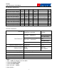
Table B-2 contains the values for the following example:
$GPGGA,161229.487,3723.2475,N,12158.3416,W,1,07,1.0,9.0,M,-34.2,M,,0000*18
Table B-2 GGA Data Format
Name Example Units Description
Message ID $GPGGA GGA protocol header
UTC Time 161229.487
hhmmss.sss
Latitude 3723.2475 ddmm.mmmm
N/S Indicator N N=north or S=south
Longitude 12158.3416
dddmm.mmmm
E/W Indicator W E=east or W=west
Position Fix Indicator
1 See Table B-3
Satellites Used 07 Range 0 to 12
HDOP 1.0 Horizontal Dilution of Precision
MSL Altitude 9.0 meters
Units M meters
Geoid Separation
1
-34.2 meters Geoid-to-ellipsoid separation.
Ellipsoid altitude=MSL Altitude + Geoid
Separation
Units M meters
Age of Diff. Corr. second Null fields when DGPS is not used
Diff. Ref. Station ID 0000
Checksum *18
<CR><LF> End of message termination
Table B-3 Position Fix Indicator
Value Description
0 Fix not available or invalid
1 GPS SPS Mode, fix valid
2 Differential GPS, SPS Mode , fix valid
3 Not supported
6 Dead Reckoning Mode, fix valid
Note:
A valid status is derived from all the parameters set in the software. This includes the minimum