
User Manual


EM-506
High Performance GPS Module
- 8 -
number of satellites required, any DOP mask setting, presence of DGPS corrections, etc. If the
default or current software setting requires that a factor is met, then if that factor is not met the
solution will be marked as invalid.
GLL - Geographic Position-Latitude/Longitude
Note – Fields marked in italic red apply only to NMEA version 2.3 (and later) in this NMEA
message description
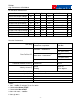
Table B-4 contains the values for the following example:
$GPGLL,3723.2475,N,12158.3416,W,161229.487,A,A*41
Table B-4 GLL Data Format
Name Example Units Description
Message ID $GPGLL GLL protocol header
Latitude 3723.2475 ddmm.mmmm
N/S Indicator n N=north or S=south
Longitude 12158.3416 dddmm.mmmm
E/W Indicator W E=east or W=west
UTC Position 161229.487 hhmmss.sss
Status A A=data valid or V=data not valid
Mode A A=Autonomous, D=DGPS,
E=DR
N=Output Data Not Valid
R= Coarse Position
1
S=Simulator
Checksum *41
<CR><LF> End of message termination
1. Position was calculated based on one or more of the SVs having their states derived from
almanac parameters, as opposed to ephemerides.