
User manual

Guidance
154
With the
map display
the TMC symbols of the traffic obstructions are shown at the
corresponding positions. With small map scales (50 km / 100 km) you can see an over-
view of the traffic information. Traffic conditions are shown in detail for larger map
scales.
Traffic messages that are on the
planned route are shown with a red
border and those off the route are
shown with a grey border.
In addition, arrows in the TMC sym-
bols can indicate the direction of
travel where the traffic obstruction
occurs for obstructions which are
not on the planned route.
Traffic obstructions that extend over a certain distance are indicated with the driving
direction and length on larger map scales, e.g. construction work, accidents, slow-
moving, queuing or stationary traffic, etc.
The traffic density (slow-moving, queuing or stationary traffic) and the length of the
traffic obstruction is then represented by arrows.
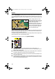
The following information is shown in the
guidance display
:
TMC symbol: Symbol of the traffic obstruction (see TMC symbols on
page 168); if there are several obstructions, then this is indicated by a second
(partly hidden) TMC symbol.
d
+ Dimensional details (red): Length of the traffic obstruction or distance to
end of the obstruction (car in the area of the obstruction).
!
Direction: Distance to the beginning of the traffic obstruction (omitted in the
area of the obstruction).
"
Simplified graphic representation of the route (black bar) and position of the
traffic obstruction (red segment). The car position is represented as circle with
arrow on the inside (driving direction).
DE-IT-E_MO_MS5000.book Page 154 Sunday, November 7, 1999 10:57 PM