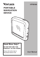
HPS9308 PORTABLE NAVIGATION DEVICE Need More Help? DO NOT RETURN THIS PRODUCT TO THE STORE Please visit online help at http://www.venturer.
Thank you for choosing this Navigator as your door-to-door in-car navigator. The memory card version is very easy to use. Read the Quick Start Guide first and start using this Navigator right away. This document is the detailed description of the software. Although this Navigator can easily be discovered by experience, it is still recommended that you read through this manual to clearly understand the exact function of each button and icon.
2 General Information This Navigator is a navigation system optimized for in-car use. It provides door-to-door navigation for both single and multi-point routes using adaptable route parameters. This Navigator is capable of planning routes throughout the whole map region installed on the memory card. Unlike some other products, this Navigator does not require that you change maps or switch to a poorly detailed general map to navigate between map segments or countries.
Table of Contents ....................................... 23 6.3.9 Visible POIs (Point of Interest) ........................ 24 6.3.10 Elements of the Action Route ............................ 26 6.3.10.1 The Start Point, Via Points and the Destination ......... 26 6.3.10.2 Animated Turn Guidance ................................. 26 6.3.10.3 The Active Leg of the Route ........................ 26 6.3.10.4 Inactive Legs of the Route ................................. 27 6.3.10.
6.5.13 Cursor Menu (No. 15) ... 38 6.5.14 Current Street (No. 16) .. 40 6.5.15 Travel and Route Data (No. 17) ................................ 40 6.5.16 Distance to Next Turn (No. 18) ................................ 41 6.5.17 Next Street / Next City (No. 19) ................................ 41 6.5.18 Approaching Next Turn (No. 20) ................................ 41 6.7.4 Main Button ..................... 58 7 Settings ................................ 59 7.1 General Settings ............ 59 7.1.
........................................ 77 7.6.5.1 Backup Data ............ 78 7.6.5.2 Restore Data ........... 78 7.6.5.3 Remove Pins ........... 78 7.6.5.4 Clear Data ............... 78 7.6.5.5 Reset Advanced Settings ................... 78 7.4.4.4 U-turns ..................... 69 7.4.4.5 Permit Needed ......... 69 7.4.4.6 Toll Roads ................ 69 7.5 Language and Navigators ..... ........................................... 70 7.5.1 7.5.2 7.5.3 7.5.4 Program Language .........
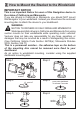
3 How to Mount the Bracket to the Windshield IMPORTANT NOTICE This is an Important Notice for users of this Navigation device in the states of California and Minnesota. If you are driving in California or Minnesota, you should NOT mount this Navigator to your windshield. Instead you should use the enclosed mounting disc to attach the device to your dashboard.
Mount the Bracket to the Windshield 2 1 mounting bracket 3 5 To windshield 4a 6 suction release 4b -8-
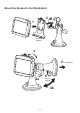
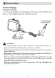
4 Connection Power Supply Using a Car Plug A 12V car plug allows the Navigator to be used with vehicles that have a 12V, negative ground electrical system. To the Cigarette Lighter Socket To Mini USB Car Plug CAUTION • Use this Navigator only with the included car plug. Use with other car plugs could damage the Navigator or even your vehicle. • The included car plug is for use with this Navigator only. Do not use it with other equipment.
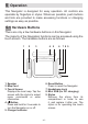
5 Operation This Navigator is designed for easy operation. All controls are operable by fingertips or stylus. Wherever possible, push buttons and lists are provided to make accessing functions or changing settings as easy as possible. 5.1 Hardware Buttons There are only a few hardware buttons on this Navigator. The majority of the Navigation functions can be accessed using the touch screen. The hardware buttons are as follows: 1 2 3 1. Speaker 2. Map Card 3. Touch Screen Displays the local map.
5.1.1 Turn On the Navigator If the device power is turned off while this Navigator is running, when you turn the device back on, this Navigator will continue the navigation as soon as the built-in GPS determines the location again. Press the button and hold for 2 seconds to turn on the Navigator. While the device is switched off, the GPS will not work. No position will be calculated, the track log will not be saved, and navigation will stop. Select Navigation 5.1.
5.2 Screen Buttons and Controls The primary input channel of this Navigator is the touch screen. If you read on, you will realize that most parts of the screen are not only used to display information but also to initiate functions by tapping. Below you will find a list of the most frequently used controls in the program. 5.2.1 List Selectors 5.2.
5.2.3 Switches When a function can only have two values (mainly Enabled and Disabled), a switch is used. Unlike with list selectors, the horizontal line contains the name of the function and not the actual status. There is a lamp on the left to show whether the function is active or not. When the lamp is dark , the function is not selected. When it is lit , the function is enabled. The whole strip works as a button. Tap anywhere to toggle between the enabled and disabled status. 5.2.
The special keys described in the previous section are also available here. Space ( ) to enter more words, and hit Done ( ) to finish entering the text. 5.2.5.3 The Numeric Keyboard The numeric keyboard only contains numbers only, on large buttons. The special keys you find on the other keyboards (except Space) are available here as well. This type of keyboard has large, finger-friendly buttons. If you are used to computer keyboards, you may consider trying the QWERTY-type keyboard. 5.2.5.
6 Discovering the Program Through the Screens The best way to discover this Navigator is to explore each screen in detail, and to find out how to move from one to another. Read this chapter for a guided tour. 6.1 Main Menu This Navigator starts by displaying the Main Menu. This is the root of the screen hierarchy, but you rarely will you need to return here while using the program. Screens are also accessible from each other to reduce the number of actions needed to initiate a function or change a setting.
6.2 About Screen Tap About on the Main Menu screen to open this screen. Information displayed here includes map licenses, the creators of this Navigator and the legal aspects of using the program. 6.3 The Map The most important and most frequently used screens of this Navigator are the two screens with the map (Map screen and Cockpit screen). They are similar in look and in possible controls but are optimized for different uses. The map they display is common. The elements of the map are described here.
6.3.1 2D and 3D Map Views It is easy to change between 2D and 3D modes. You have two options. You can use the Tilt up and down button (6.5.3.) to tilt the map seamlessly between 2D and all 3D angles, or you can use the switch in the Quick menu (6.7.2) to quickly switch between the two modes.
Changing the scale of the map is very easy. You can drag and stretch the scale (6.5.6) at the bottom of the Map screen, or use the semi-transparent screen icons (6.5.2) on both Map and Cockpit screens. 6.3.2 Zoom Levels This Navigator uses high quality vector maps that let you see the map at various zoom levels, always with optimized content (the density of the map details can be independently set for Map and Cockpit screens in Map settings (7.2)).
6.3.3 Day and Night Color Schemes NOTE: The automatic day/night mode is based upon the current date and GPS position by which this Navigator calculates the exact sunrise and sunset times on the particular day at the particular location. Using that information this Navigator can automatically switch between the color schemes a few minutes before sunrise, when the sky has already turned bright, and a few minutes after sunset before it gets dark.
TIP : If you use this Navigator after sunrise or before sunset, look for the sun in the sky in the map background using a flat 3D view. It is displayed at its actual position to give you another way to orientate your direction. Navigator uses two different ways to show street labels. The conventional way is the same as a roadmap - it displays the name of the street aligned with the street. The alternative is a kind of virtual signpost embedded into the street itself.
display off (7.2.4) to free some of the resources of your PNA by replacing textures with plain colored surfaces. NOTE: The automatic switching is on even when using Smart Zoom. At first you may find it odd, but later you will discover how it adjusts the displayed information to the current view on the map. It is important, as the driver must be able to read the map at a glance. TIP: If you do not want to be bothered by street names during navigation, turn them off in the Map Options (7.2).
turned off in advanced settings (7.6.4.5) for pedestrian use. When switched off, the arrow is displayed at the position reported by the GPS receiver. When the GPS position is lost, the arrow turns grey, but the journey continues on the recommended route for a short period of time with the speed last detected before the GPS position was lost. When the next route event is reached, or after 40 seconds, the arrow stops, and remains gray until GPS reception returns.
6.3.8 Marked Map Points (Pin) it as a POI. The cursor, when visible, is also the reference point for map scaling. The Cursor can be marked with a pin. Pins are shown as being stuck in the map. A pin is visible at all zoom levels and remains in its position until you unpin it, or delete all pins in advanced setting (7.6.5.3). NOTE: When your GPS position is available, and Lock-to-Position (6.5.4) is active, the cursor is the current GPS position, the blue arrow).
This Navigator automatically selects the color of the pin. Different colors help you identify a pin in the History list (8.3.2) later. There they are shown together with their address and GPS coordinates. TIP: A quick way to tell the coordinates of a location you found on the map is to pin it, and then look for the coordinates in the History list (8.3.2). This way you also save the coordinates with the pin for later reference.
TIP: Tap the map on or near a POI item to see the list of the names of the nearest POIs in a popup list, if it is enabled (6.7.2.5). To see the details of a particular POI in the list, tap the blue “i” icon on the right. If you have too may POIs nearby, this list may not be complete. In the Cursor menu (6.5.13) there is a button called POI that leads you to the screen of all nearby POI items. There you can open them one by one to see their details, and select any of them as a route point.
6.3.10 Elements of the Active Route 6.3.10.2 Animated Turn Guidance This Navigator uses a multidestination routing system in which you have a start point (your current location if GPS position is available), a destination, the line of the active leg of the route, and optionally via points and inactive legs. They are all shown on the map. Animated arrows represent all route events other than the above-mentioned special points. These arrows shown the direction you need to travel to continue your journey.
as soon as you reach its starting begin to approach the point. The line of the route is displayed on the driving side of the road for two-way and on the axis in case of one-way streets. When the map is zoomed in and the line is wide enough, small arrows show the direction of the route. This can be useful if you preview the route before starting the journey or when entering a complex junction. 6.3.10.
6.4 GPS Data Screen Tap the small satellite dish icon on the Main Menu, Map or Cockpit screen to open this window.
6.4.1 GPS Data Displayed 6.4.2 GPS Connection Indicator The virtual sky on the left represents the currently visible part of the sky above you, with your position as the center. The satellites are shown at their current positions. The GPS receives data from the green and grey satellites but not from the red ones. Signals from the grey satellites are only received, while green ones are used by the GPS to calculate your current location. On the right you can see the satellite signal strength bars.
Red means the GPS is connected but no GPS position is available. Yellow means 2D reception. A GPS position has been acquired, and the Navigator is ready for navigation, but the GPS is not using enough satellites for calculating the horizontal position. Elevation data is not provided, and the position error may be significant. Green means 3D reception. The GPS receiver has enough satellites to calculate altitude.
6.5 Screens with Map Having explained the contents of the map, the description of the other parts of the map screens follows. There are two map screens: the Map screen and the Cockpit screen. The way they show the map is the same but their look and controls are optimized for different purposes. The Map screen is to be used mainly without a GPS, to browse the map, create user POI items, or to plan your route based on map points. The Map screen is designed to give you the maximum map area.
11 12 13 14 15 16 17 GPS position Battery status Sound on or muted Track Log recording or playback Opens GPS Data screen Opens settings Enables/disables muting Opens Track Log screen Opens Cursor menu Opens Route Information screen Opens Route Information screen (Cockpit only) Current street (Cockpit only) Travel and Route data** 18 (Cockpit only) Distance to next turn*** 19 (Cockpit only) Next street*** 20 (Cockpit only) Approaching next turn**** N/A N/A N/A * On Map screen only when a route is active
6.5.1 Turn Preview (No. 1) 6.5.2 Zoom In and Out (No. 2 and 3) On the Cockpit screen this field shows a graphic illustration of the next maneuver. For example when you approach a turn, an arrow will show whether it is a slight, normal or sharp turn. When showing a roundabout, the number of the exit is also given in the picture. These semi-transparent buttons are only displayed if ‘Zoom & Tilt’ is enabled in the Quick menu (6.7.2.2).
6.5.3 Tilt Up and Down (No. 4 and 5) 6.5.4 Follow Mode - Lock to GPS Position and Heading (No. 6) These semi-transparent buttons are only displayed if ‘Zoom & Tilt’ is enabled in the Quick menu (6.7.2.2). This semi-transparent icon is displayed if the GPS position is available, and the map has been moved. It also appears when you scale or tilt the map while Smart Zoom is enabled. This function modifies the vertical viewing angle of the map in 3D mode.
6.5.6 Map Scale (No. 8) button for you on the cockpit screen automatically. This can be turned on for re-enabling both Lock-to-Position and Smart Zoom. The scale indicator is only available on the Map screen. In 2D map view it represents the scale of the map. In 3D view it is the scale of the nearest part of the map only. 6.5.5 Cursor (No. 7) As described in 6.3.
You can set this Navigator so that it will switch to Overview mode during navigation when the next turn is far away. You can specify this distance and the fixed zoom level of Overview in Advanced setting (7.6.3.2). An airplane icon indicates Overview mode. Tap the icon again to return to Track-up (automatic rotation) mode. this Navigator rotates the map during navigation to always face the direction of your travel. In this mode an arrow (compass) points towards North.
Black shows there is a GPS position, and navigation is possible. When only one arc is shown , the position is 2D (no altitude available), and position error may be significant, yet this Navigator is ready to navigate. A black dish and two arcs represent a 3D GPS position. This Navigator is ready to navigate. 6.5.10 Battery Status (No.12) 6.5.11 Sound Muting (No.13) By tapping this button you can quickly mute all sounds of the PNA.
6.5.12 Track Log Recording/Playback Indicator (No.14) use the Cursor for. At the same time Popup Info (street name, house number and the list of POIs nearby) appears near the selected map point if Popup Info is enabled in the Quick menu (6.7.2.5). If you do not use the Cursor menu in a few seconds, it will automatically vanish back to the bottom of the screen, and Popup Info disappears, too . You can have them reappear by reopening the Cursor menu using the arrow in the bottom right corner.
point as a via, you instruct this Navigator to cross this location before the destination of the route. This is the way to build a multi-point route in reverse order (when you wish to insert a stopover ‘go to A but first get some fuel at B’ or want to influence the direction of the route). This menu point works only if a route is already active. The content of the Cursor menu depends on the screen (Map or Cockpit) and it is slightly different if there is an active route already planned.
6.5.15 Travel and Route data (No. 17) the History list together with its exact position. This Navigator automatically selects the color of the pin. The contents of these three fields are different when cruising (without an active route) or navigating (following an active route). While cruising, the fields show the present speed, the current speed limit and the time of day.
• Time to next maneuver (next route event) • Speed • Speed limit • Arrival at next via point • Arrival at destination (default value for the right field) 6.5.16 Distance to Next Turn (No. 18) This field shows the distance to go before reaching the next route event (turn, roundabout, exit, etc.) This field is only displayed when navigating a route. This field is only displayed when navigating a route. 6.5.17 Next Street / Next City (No. 19) 6.5.18 Approaching Next Turn (No.
6.6 Route Information Screen The Route Information screen has all the data and some of the functions you need while you navigate. Some additional functions can be found in the Route menu (6.7.3). Without an active route one of the buttons is inactive and route data cannot be displayed. As a reminder, you can open this screen two ways: tapping the Info button in the Route menu (6.7.3.6), or tapping one of the Route Data fields on the Cockpit screen. 6.6.
6.6.1.1 Route Line The upper part of this screen shows your planned route as a horizontal line. The point farthest to the left is the start of the route and the point farthest to the right is the final destination. You can see your via point flags along the line, spaced in proportion to their distance. The blue (yellow at night) arrow representing your position will travel from the left to the right, giving you visual feedback of your journey.
6.6.1.6 Destination / Via Point This field shows the exact address (or its coordinates if the address is not available) of the final destination. If a via point exists, tap and tap again any of the fields to see the address or coordinates of the first, second, etc. via point. 6.6.1.4 Time Left This is an estimated value that can also be displayed in one of the Route data fields on the Cockpit screen as ‘Time to destination’.
This icon shows that toll roads are included in the recommended route. This icon shows that you need to board a ferry along the recommended route. This icon shows that you need to pay for the ferry. This icon is displayed when this Navigator could not plan a route with all your road type preferences respected. Sometimes it is impossible to find a suitable route near the start or the destination.
6.7 Menu Tapping this button brings up a menu that allows you to access some of the most frequently used functions of this Navigator. conventional top-down view. This 2D view is also the end of the tilt range, so tilting the map up can also access it. Conversely, 3D mode can be switched on by tilting down in 2D mode. Map view modes are described in 6.3.1. 6.7.1 Find Tab This first page of the Menu is Find tab. It lets you select a destination without first having to locate it on the map.
6.7.2.3 Night Mode (Switch) Turn on or off the night colors to override the automatic color scheme switching. If the map is zoomed out so that the view angle is automatically raised to a top down view, this button will have no immediate effect. When you zoom back in, the view angle will or will not change according to the new state of the button. 6.7.2.2 Zoom & Tilt (Switch) When the light is on, additional transparent buttons (6.5.2 and 6.5.
Manage Built-In POI Visibility The maps in this Navigator come with a huge number of POIs. Displaying all of them would make the maps too crowded. In order to avoid that, you can decide which POI groups to show and which ones to hide on the map. This Navigator has a multi-level POI category system. You can set the visibility of the top two levels. All levels below that will be shown or hidden according to their respective category (i.e.
Manage My POI By highlighting then tapping again the My POI switch on the Manage POI main screen, you can manage the POI groups and items that you have created. 219 Midland Rd, Midland, WA 6055 5048 Lochinvar Rd, Memphis, TN 38116 238 E 8th St Long Beach, CA 90813 235 Park Ave S, New York, NY 10003 When the My POI Groups are displayed, you have the following options: Show/Hide Similarly to built-in POIs, you have the possibility to show or hide all POIs of the selected category on the map.
groups. This will delete all POIs in that group. This Navigator will ask you to confirm this action. Edit You can edit the attributes (name, icon, visibility level) of a previously created My POI group. display the list. If you tap Done any time before this happens, you receive the list of matches on multiple pages. ABC/Distance By tapping this button you can have the POIs sorted in alphabetical order. Tapping again will return to the distance based order.
names shows the details of the appropriate POI item. 6.7.2.6 Manage Track Logs Using this Navigator, it is also possible to save the track logs of your journeys. This screen lets you manage all your track logs. When it comes up, it shows a list of all track logs already saved. Delete You can delete any of your previously saved POIs. This Navigator will ask you to confirm this action. 6.7.2.
be drawn on the map using the color next to its name. in the list, and GPS position data will be saved until you stop the recording or exit this Navigator. A red icon (6.5.12) is shown on the map screens to let you know that a recording is in progress. Tapping that icon opens this Track Log screen. Stop Recording If recording is in progress, this buttons stops it.
log on the map. A green icon (6.5.12) will appear on the map screens to let you know it is a simulation only. 6.7.3 Route Tab This menu contains options to manage different settings in the program. Recalculate This function repeats the route calculation based on the previous setting. This possibility is typically used when automatic off-route recalculation is disabled. However you may consider using it when you travel on a road parallel to that recommended by the route.
already almost reached it, and this Navigator still keeps on navigating towards that point. When there are no via points left (only the destination), the name of this button turns to Delete Route, and it cancels the navigation. use the Avoid function in Itinerary instead (6.7.3.3). When you use this feature, this Navigator will keep on excluding the same part of the map from later routes until you manually delete the route (6.7.3.2), or restart this Navigator.
one until you highlight another one by tapping it. After that, the highlight remains on the item you have selected. Detailed Instructions map and navigation stops. The route is now practically deleted, but if you plan a new route, the roads, maneuvers and areas excluded from your route will also be avoided when planning the new route. Tap Delete to completely delete your previous route together with its Avoid restrictions. This is the list displayed when Itinerary is opened.
important in the route, it is likely that this Navigator will replace the turn with several easier ones to get to the same street. • Road : When you exclude a road, this Navigator will calculate a route that does not use that road. It is useful when you anticipate a traffic jam in a street used in your route, or a roadblock is announced on the radio, and you find that road in your itinerary. • Distance : You can also find some distance buttons in this list.
6.7.3.4 Fly Over This feature has no navigation function; it merely provides a quick view of the route. It will present a simulation of the route showing what you will see later when navigating. Lifelike Simulation Tap the Fly Over button. In this mode the simulation is run at normal speed (using the speed limit of the streets and roads in the route), and voice instructions are also played.
6.7.3.6 Info This button opens the Route Information screen described in 6.6. This screen shows information about the current route and has a few additional options to check and modify your active route. • Optimize : You can optimize the order in which you will drive through the via points, if there is no specific order you would like to keep. When tapping this button, this Navigator reorders the list instantly to save you time and fuel. Optimization is for via points only.
7 Settings This Navigator provides several settings in order to let you customize the functions of the program. The Settings screen can be accessed directly from the Main menu screen (6.1) and from the map screens by using the battery icon (6.5.10), while some of its sub-screens are accessible from other parts of the program. 7.1 General Settings These are the basic settings of this Navigator. 7.1.
7.1.2 Set Favorite Destinations You can select two of your most frequent destinations to be your favorites (8.3.5). You can start navigating to either of them by only two taps on the screen. The original names of these points are Home and Work. NOTE : If you tap either of your favorite destinations in the Find menu (8.3.5) before defining it, this Navigator will offer to take you to this screen to set it up. 7.1.3 Automatic Night Colors You can rename them and specify their locations.
7.1.4 Alerts Tap this button to enable and fine tune user alerts. A new window opens with the options. Speeding Tolerance This Navigator will warn you when you exceed the speed limit by the amount specified here. Select whether you want to specify the tolerance as a Fixed value (offset to the speed limit) or as a Percentage. The slider will change depending on which mode you have chosen. Both positive and negative values can be given in either offset or percentage mode. 7.1.4.
Alternative Speeding Tolerance If the speed limit of the current road reaches the value set at Alternative speed limit, this setting will replace the basic one set at the top of this screen. The slider and the selector works exactly like the basic ones described in 7.1.4.1. 7.1.5 Route Recalculation Once a route is planned, this setting will tell this Navigator what to do when you deviate from that route. 7.1.5.1 Automatic The route will be recalculated automatically a few seconds after you go astray.
7.1.5.2 Ask First This Navigator can also ask your preference each time you leave the planned route. The route will not be recalculated until you make your choice from the menu that automatically appears. from the list and recalculate the route without it. If you have only one target left, the label of the button will be Delete Route, and it will end navigation.
7.2 Map Settings You can set a few parameters determining the appearance of the maps in this Navigator. 7.2.1 Day / Night Color Profile This Navigator comes with different color schemes for both day and night use. There is always one selected daytime scheme and one selected nighttime scheme. This Navigator uses these when switching from day to night and back. Tap the appropriate button and select a new scheme from the list. 7.2.
7.3 Sound Settings Settings on this page determine the way this Navigator sounds. NOTE : The Mute function (6.5.11) accessible from the map screens override the settings on this screen. When this Navigator is muted, all sounds disappear. These settings will not be changed; only the output will be muted temporarily. 7.3.1 Master Sound Volume / Switch will change the status of the other. The loudness of this Navigator is independent of your PNA settings.
7.3.3 Key Sound Volume / Switch 7.3.4 Dynamic Volume The switch on the left can turn the key sounds on or off. Key sounds are audible confirmations of either pressing hardware buttons or tapping the touch screen. When key sounds are turned on, the slider on the right will adjust their loudness. In its leftmost position the key sounds are suppressed; in its rightmost position they are played at the master volume level. NOTE : The sound effects of this Navigator are context sensitive.
7.4 Route Parameter Settings This is a very important page. Settings here determine how routes will be calculated. This screen is directly accessible from the Route Information screen (6.6). 7.4.2.1 Fast Choosing Fast will result in the quickest possible route, given that you can travel at or near the speed limits on all included roads. This is usually preferred for fast and normal cars. 7.4.1 Method Use the handle to set the speed of the route calculation.
7.4.3 Vehicle NOTE : Excluding a route is a preference. It does not necessarily mean total prohibition. If your destination can only be accessed using some of the excluded road types, this Navigator will use them but only as much as necessary. In this case a warning icon will be shown on the Route Information screen (6.6), and the road not matching your preference will be displayed in an alternate color on the map. You can set the type of vehicle you will use to navigate the route.
7.4.4.5 Permit Needed To use some roads or enter some areas you may need a special permit or permission from the owners. These roads are excluded from your routes by default. Use this switch if your vehicle is authorized to enter. 7.4.4.4 U-turns Although displayed amongst road types, this is a type of action. Most drivers prefer to replace them with a few normal left and/or right turns in the next few junctions, so it is disabled by default. Turning back on dual roadways is not considered a u-turn. 7.4.
7.5 Language and Navigators Here you can set the languages, measurement Navigator, and date and time formats used by this Navigator. 7.5.1 Program Language This button displays the current written language of the program. By tapping the button you can select from a list of available languages. This Navigator will have to be restarted if you change this setting. This Navigator will ask for confirmation before it restarts. 7.5.3 Navigators 7.5.
7.6 Advanced Settings These screens let you set a large number of different advanced settings and initiate some special functions. These settings and functions are divided into groups. Tap on any button to set the corresponding parameters. They all open new windows where you can make your desired changes. 7.6.1 Display Options These settings determine how this Navigator displays different content elements or how it presents the screens.
7.6.1.2 3D in Cockpit Mode (and Track-up Orientation) The normal use of Cockpit mode is cruising or navigating, when the road lying in front of the driver is the most important part of the map. It is usually done in a 3D view with the current direction towards the top of the map. By default this Navigator uses the same look of the map in both Map and Cockpit modes.
7.6.2 Backlight Settings you achieve a longer battery life. Here you can set how the display backlight behaves when using this Navigator. These settings are independent of the settings of the other applications of PNA. 7.6.2.2 Brightness You can set the backlight level separately for both day and night modes, thus enhancing the effect of the night color scheme. The values are between 0 and 99, where zero means there is no backlight at all, and 99 represents the maximum backlight value. 7.6.
These automatic features can be personalized on this screen. of the map in both automatic and manually selected (by the Map orientation icon -- see in 6.5.8) Overview modes. You can change the zoom level manually at any time (the Follow button will not be displayed), but when you enter the Overview mode again, the zoom level will be reset to this value. You can also move the map in Overview mode.
Zoom mode by tapping the Follow button. If you move the map, all parts of Smart Zoom become deactivated, and the view freezes. Tapping the Follow button makes this Navigator follow your position again (Lock-to-Position) and also re-enables Smart Zoom. You can make this Navigator push the Follow button for you automatically after a few seconds of inactivity. This functionality and the related parameters below apply to the Cockpit screen only. The Map screen will wait for your action.
7.6.4 Route Options fluctuation) of the calculated GPS position is likely. Although this Navigator employs a sophisticated Follow-onRoad system that will mostly suppress these position errors by aligning your position to the recommended route and the road network of the map, sometimes the errors are too large to correct. To reduce the effect of large errors, you can increase the recalculation tolerance two ways. You can set the basic route parameters on the Route Parameter settings screen described in (7.
7.6.4.2 U-turn Penalty You can fine-tune the way this Navigator takes u-turns into account when planning a route. You can tell this Navigator how much extra distance you would travel to avoid a u-turn. seamlessly correcting small GPS errors. For pedestrian use you may consider disabling Lock-on-Road to make this Navigator always show your exact position. NOTE : By turning off Lock-on-Road you also turn off the GPS position error searching.
7.6.5.1 Backup Data You can make a safe copy of the whole user database on the memory card. Tap this button to copy all user data to the memory card. The backup is always created with the same file name; so backing up data will always overwrite previous backups. of this Navigator to the latest backup. By tapping this button you will lose all of the changes made since the time of the latest backup. This Navigator will warn you about this before overwriting the current database with the backup. 7.6.5.
8 Find One of the most frequently used functions of this Navigator is selecting the destination. Once you have the destination, you can start navigating. Getting to this point should be as fast as possible. This Navigator provides you with a versatile search engine designed to find your chosen destination after only a few taps on the screen.
8.3.1 Find an Address, Street, Intersection or City TIP : If you want the selected point shown in the center of the map, close and reopen the menu or wait until it closes and open it again. By opening the Cursor menu manually, the map will be moved to have the selected location in the center. Searching for a city, a street, an intersection, or an exact address can all be done in the Find Address module. If you know at least a part of the address, this is the quickest way to find the location.
8.3.1.1 Selecting the City, State and Country to Search In The first screen of the address search module is the list of recently used cities. The first line of the list is always the city you are in or closest to. GPS position is available, and you have not disabled Lock-to-Position by moving the map. If you find that the list of recently used cities contains cities you will not visit in the near future, you can choose to empty the list by the Clear button in the bottom left corner.
You can accomplish this by using an alphabetic input screen (either an ABC- or QWERTY type). You only need to enter the first few letters, as the program only searches among the cities that exit in the given state or country. If the name of the city is of more than one word, the searched pattern can be any or a combination of those. You can search for multiple partial words by inserting space characters in the pattern.
Changing the State Some of the maps contain state information. If the city you are looking for is in a different state, tap Other City then Change State from the list of recently used cities, then select the appropriate state. Should you wish to search for an address in the whole country, just tap “Change state” at the beginning of the list. 1/11 Once you have selected the city, you can continue by entering the street name.
8.3.1.2 Selecting a Street or the Center of the City Once the city is selected, you can continue by specifying the street you are looking for. Note: As for the street input, only available letters are active when entering the first word of the street name . All other letters are inactive and grey. intersection in a small town or village, and for larger cities an important intersection in the city center.
8.3.1.3 Selecting a House Number or the Midpoint of the Street Once the country, the city and the street name are selected, you are asked to give the house number using the numeric keypad. The range of available house numbers for the chosen street is shown in the input field before you begin entering the figures. Streets and Pine Roads. Should the name of the street be a prefix for several other street names, just enter the whole name, press done, and the exact match will be the first in the list.
8.3.2 Find in History 8.3.1.4 How to Select an Intersection Instead of a House Number If you do not know the house number or it is easier to pinpoint the location with an intersection, press the Find intersection button in the top right corner and select the desired street name from the list of available intersections of the previously selected street (displayed in the top center of the screen). The crossing of the two streets will be the selected point.
8.3.3 Find Coordinate the point is the Northern or the Southern hemisphere. Use the button to change the hemisphere. Enter numbers for the latitude. Use the decimal point if the degrees, minutes or seconds are not integers. Use the / button (the label depends on the current cursor position inside the latitude) to start entering minutes after degrees or seconds after minutes. This Navigator also lets you enter your destination by map coordinates.
coordinates in the format you have, press done to show it in he map, then come back here to see the same location in the chosen coordinate display format. To change the reference, tap the Change ref. button in the top right corner. 8.3.4 Find a POI You can select your destination from the thousands of POIs included with this Navigator or from the ones you have previously created. This screen helps you find the one you are looking for. POI items are categorized to let you locate them more easily.
Cursor : The search will be carried out around the previously selected map point. of POIs. If you tap Search in the list of subgroups, you will only search in the group you are already in. Destination : The search will be carried out around the destination or your current route. See all POIs of the Current Group in a List : Tapping the all button opens the list of all points in the group or subgroup you are already in. Use the Next and Previous buttons to browse through the list.
8.3.5 Find a Favorites Location Once the desired POI item is selected, this Navigator will show its details. If you have already set up your favorite destinations in General settings (7.1.2), you can select either of them by simply tapping the button with the name on it. Using the Find and GO function at the Main menu it is only two taps to starts navigating to one of your Favorites.
9 Troubleshooting Guide Thank you again for purchasing our product. We hope you will enjoy every minute of using it. However you may face difficulties before you get really accustomed to the Venturer GPS Navigation. In such cases, please refer to this table of frequently encountered problematic situations. I cannot find the blue (yellow when using night colors) arrow that would show my location. Navigation does not start.
The ‘Route To’ button is for starting a new route only. For a single route you tap this when the destination is selected. Multi-point routes can be created after you have established a single route. Add points to the single route by using the ‘Add Via’ and ‘Continue’ buttons. Applying ‘Route To’ again will delete the whole route. In your case only single routes existed before, so they were deleted without a warning message.
10 Glossary The manual may contain many technical terms. Please look below for an explanation if you are unfamiliar with some of them. 2D/3D GPS Reception: The GPS receiver uses satellite signals to calculate its (your) position. Depending on the current positions of the ever moving satellites in the sky, and the objects in your environment, the signal that your GPS device receives may be weaker or stronger.
you deviate from it. When you miss a turn or avoid a roadblock, Venturer GPS Navigation waits for a few seconds to be sure you do not follow the route any more (you can fine-tune it in Advanced settings), then recalculates the route based upon your new position and direction. Automatic Day / Night Colors: Based on the time and position given by the GPS device, Venturer GPS Navigation is able to calculate when the sun rises and sets at your current location on this particular day.
received from those GPS satellites that are currently visible at your location. You can use this service free of charge. Lock-on-Road: This function of Venturer GPS Navigation will always keep the blue (yellow when using night colors) arrow representing your actual position on the nearest road. This automatic feature is necessary as the position given by the GPS receiver is not perfectly accurate. Under normal circumstances Lock-on-Road will eliminate the occasional position error.
Track Log: In Venturer GPS Navigation you have the possibility to record your journeys using the position data your GPS provides in every second or every few seconds (depending on your GPS settings). When you start the recording, position data is saved in the database until you stop recording it. This set of sequential GPS positions is called track log.
11 End User License Agreement 1. The Contracting Parties 2. Conclusion of the Agreement 1.1. 2.1. 2.2. 2.3. 2.4. 2.5. 3. 3.1. 3.2. 4. 4.1. 4.2. 4.3. Contracting parties to present Agreement are, on the one hand: Nav N Go Kft (reg.no.: 03-09-111944) as Licensor and the legal user (as defined in Section 2) of the object of present Agreement according to Section 4, hereinafter referred to as User on the other hand (hereinafter jointly referred to as Parties).
4.4. 5. 5.1. 5.2. 5.3. 5.4. 5.5. 6. 6.1. 6.2. 7. 7.1. graphic display, storage, source or object code of the software product, or any other as yet indefinable form of display, storage, or coding, or any medium thereof shall be deemed as part of the software product. Error corrections, additions, updates used by the User as defined in Section 2 following the conclusion of present contract shall also be deemed as part of the software product.
7.1.1. to multiply the software product (to make a copy thereof); 7.1.2. to lease, rent, lend, distribute, transfer it to a third person with or without a consideration; 7.1.3. to translate the software product (including translation (compilation) to other programming languages); 7.1.4. to decompile the software product; 7.1.5.
8.6. 9. 9.1. special care and attention required due to utilizing the software product) is the exclusive responsibility of the User; the Licensor shall not assume any responsibility for any damages occurred in relation to utilizing the software product during transportation. By concluding present Agreement the User shall especially acknowledge the information stated in Section 8 above.