
User Guide


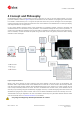
Table Of Contents
- Contents
- 1 Preface
- 2 Features
- 3 Getting Started
- 4 Concept and Philosophy
- 5 u-center Menus and Windows
- 5.1 Main frame and toolbars
- 5.2 Views and windows
- 6 NTRIP
- 7 Google Earth server
- 8 Tools
- 9 How To
- 10 Troubleshooting
- 11 Related Documents
- 12 Revision History

u-center-User Guide
UBX-13005250 - R18
Production Information 2 Features
Page 6 of 67
2 Features
u-center evaluation software provides system integrators and end users with a quick and simple way to interface
with u-blox GNSS chipsets, modules and boards. It enables easy evaluation, performance testing, development
and debugging of GNSS positioning chips and modules. u-center allows easy connection to u-blox products and
provides a suite of features to view, log, and analyze performance. The features include:
• Support for u-blox's receivers using u-blox positioning technology. u-center can communicate with these
receivers using either the UBX protocol or the NMEA-0183 standard protocol.
• Support for receivers that utilize standard NMEA strings.
• u-center presents all the information collected during the operation of the GNSS device. All aspects of
GNSS data (position, velocity, time, satellite tracking, etc.) can be monitored and logged under various test
scenarios for the evaluation of a receiver. u-center software allows analysis of the collected data in order to
investigate performance issues such as accuracy, road test position and trajectory, satellite tracking, time
to first fix, etc. All processed data can be captured in ASCII format and ported into popular spreadsheets
for creating additional plots and statistics.
• Camera View: photographic data can be stored in the log file together with the navigation data and later
be replayed in the application.
• Export data files to Google Earth and Google Maps.
• Supports (Multiple GNSS) AssistNow Online and AssistNow Offline.
• Data recording and playback function.
• Structural and graphical data visualization in real-time.
• Export functionality to standard PC applications.
• Docking views (real-time cockpit instruments): Satellite constellation, compass, clock, altimeter,
speedometer, GNSS and satellite information views.
• Download firmware updates to GNSS positioning modules.
• Support for NTRIP server and NTRIP client functionality.
• Google Earth server support.
• SQLITE database support